
Markham topographic map
Click on the map to display elevation.
Markham
Markham's average altitude is at 200 m (660 ft) and in general consists of gently rolling hills. The city is intersected by two rivers; the Don River and Rouge River, as well as their tributaries. To the north is the Oak Ridges Moraine, which further elevates the elevation towards the north.
About this map
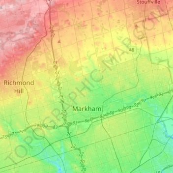
Name: Markham topographic map, elevation, terrain.
Location: Markham, York Region, Golden Horseshoe, Ontario, Canada (43.79804 -79.42873 43.96251 -79.17021)
Average elevation: 216 m
Minimum elevation: 135 m
Maximum elevation: 333 m
York Region trails, hiking, mountain biking, running and outdoor activities
Other topographic maps
Click on a map to view its topography, its elevation and its terrain.
Keswick
Canada > Ontario > York Region
Keswick's geographical coordinates are 44.22°N, 79.45°W, and its elevation above sea level is 221m/762 ft. It has a geographical area of 16.25 km² according to Statistics Canada. It is bound on the north by Roches Point, the east by Woodbine Avenue, the south by East Gwillimbury (Ravenshoe Road) and the…
Average elevation: 228 m
Whitchurch-Stouffville Community Park, Vandorf
Canada > Ontario > York Region > Whitchurch-Stouffville
Average elevation: 305 m
East Holland River
Canada > Ontario > York Region > East Gwillimbury > Holland Landing
Average elevation: 223 m
Phyllis Rawlinson Park
Canada > Ontario > York Region > Richmond Hill > Gormley
Average elevation: 252 m
Keswick
Canada > Ontario > York Region
Keswick's geographical coordinates are 44.22°N, 79.45°W, and its elevation above sea level is 221m/762 ft. It has a geographical area of 16.25 km² according to Statistics Canada. It is bound on the north by Roches Point, the east by Woodbine Avenue, the south by East Gwillimbury (Ravenshoe Road) and the…
Average elevation: 228 m