
Bloomington topographic map
Click on the map to display elevation.
About this map
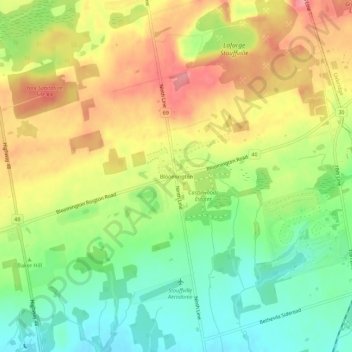
Name: Bloomington topographic map, elevation, terrain.
Average elevation: 323 m
Minimum elevation: 277 m
Maximum elevation: 372 m
York Region trails, hiking, mountain biking, running and outdoor activities
Other topographic maps
Click on a map to view its topography, its elevation and its terrain.
Whitchurch-Stouffville Community Park, Vandorf
Canada > Ontario > York Region > Whitchurch-Stouffville
Average elevation: 305 m