Geolocate

Snagov topographic map

Click on the map to display elevation.

About this map

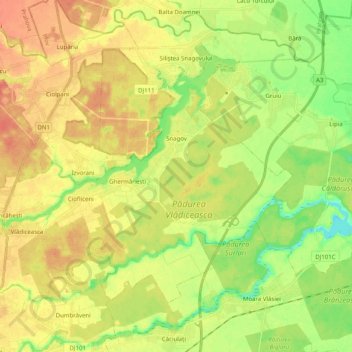
Name: Snagov topographic map, elevation, terrain.

Location: Snagov, Ilfov, Romania (44.63837 26.03893 44.74581 26.23906)

Average elevation: 92 m

Minimum elevation: 65 m

Maximum elevation: 117 m

Other topographic maps

Click on a map to view its topography, its elevation and its terrain.

Odăile

Romania > Ilfov > Otopeni

Average elevation: 96 m

Dumitrana

Romania > Ilfov > Măgurele

Average elevation: 72 m

Căciulați

Romania > Ilfov

Average elevation: 90 m

Lacul Morii

Romania > Ilfov > Bucharest

Average elevation: 85 m

Rudeni

Romania > Ilfov > Chitila

Average elevation: 93 m

Căciulați

Romania > Ilfov

Average elevation: 90 m

Ordoreanu

Romania > Ilfov

Average elevation: 86 m

Islaz

Romania > Ilfov

Average elevation: 73 m

Ghermănești

Romania > Ilfov

Average elevation: 94 m

Moara Vlăsiei

Romania > Ilfov > Moara Vlăsiei

Average elevation: 87 m

Grădiștea

Romania > Ilfov > Grădiștea

Average elevation: 82 m

Snagov

Romania > Ilfov > Snagov

Average elevation: 92 m

Gruiu

Romania > Ilfov > Gruiu

Average elevation: 87 m

Tunari

Romania > Ilfov > Tunari

Average elevation: 90 m

Săftica

Romania > Ilfov > Săftica

Average elevation: 99 m

Gear up for your next adventure:

🔦LED Flashlight - Powerful and long-lasting flashlight for camping and emergencies
🥾All-Terrain Hiking Boots - Versatile boots for varied hiking conditions
🥾Trekking Boots - Durable boots for long-distance trekking
🧥Waterproof Hiking Jacket - Protect yourself from rain and wind while hiking
🧊Portable Cooler - Keep food and drinks cold during outdoor adventures

As an Amazon Associate, this site earns from qualifying purchases at no extra cost to you.