Geolocate

Bidborough topographic map

Click on the map to display elevation.

About this map

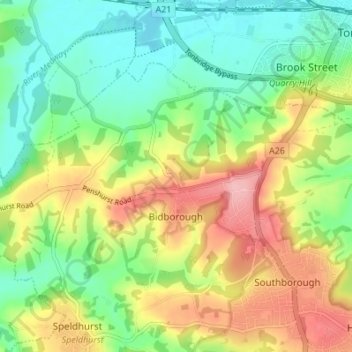
Name: Bidborough topographic map, elevation, terrain.

Location: Bidborough, Tunbridge Wells, Kent, England, United Kingdom (51.15767 0.19048 51.18522 0.25884)

Average elevation: 71 m

Minimum elevation: 18 m

Maximum elevation: 148 m

Other topographic maps

Click on a map to view its topography, its elevation and its terrain.

Cranbrook

United Kingdom > England > Kent > Tunbridge Wells

Average elevation: 76 m

East End

United Kingdom > England > Kent > Tunbridge Wells

Average elevation: 59 m

Linkhill

United Kingdom > England > Kent > Tunbridge Wells > Sandhurst

Average elevation: 22 m

Hook Green

United Kingdom > England > Kent > Tunbridge Wells

Average elevation: 86 m

Matfield

United Kingdom > England > Kent > Tunbridge Wells

Average elevation: 82 m

Hurst Wood

United Kingdom > England > Kent > Tunbridge Wells > Rusthall

Average elevation: 101 m

Brenchley

United Kingdom > England > Kent > Tunbridge Wells

Average elevation: 68 m

Iden Green

United Kingdom > England > Kent > Tunbridge Wells

Average elevation: 58 m

Langton Green

United Kingdom > England > Kent > Tunbridge Wells

Average elevation: 94 m

Hartley

United Kingdom > England > Kent > Tunbridge Wells > Hartley

Average elevation: 94 m

Kilndown

United Kingdom > England > Kent > Tunbridge Wells > Kilndown

Average elevation: 71 m

Cranbrook

United Kingdom > England > Kent > Tunbridge Wells

Average elevation: 76 m

Gear up for your next adventure:

🧥Thermal Fleece Jacket - Versatile insulation for changing mountain temperatures
🦟Insect Repellent - Keep mosquitoes and black flies away in wooded areas
🧰Emergency Multi-Tool - Compact multi-tool for outdoor survival
Backpacking Tent - Lightweight tent for long-distance hiking trips
🛰️Satellite Messenger - Emergency communication for areas with no cell service

As an Amazon Associate, this site earns from qualifying purchases at no extra cost to you.