Geolocate

Sempach topographic map

Click on the map to display elevation.

About this map

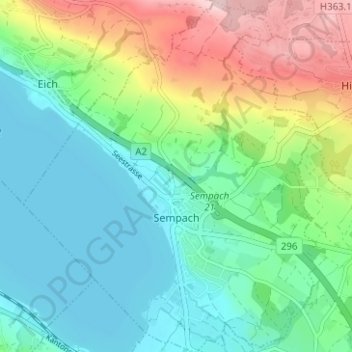
Name: Sempach topographic map, elevation, terrain.

Location: Sempach, Lucerne, 6204, Switzerland (47.11899 8.16475 47.16160 8.21744)

Average elevation: 573 m

Minimum elevation: 500 m

Maximum elevation: 743 m

Other topographic maps

Click on a map to view its topography, its elevation and its terrain.

Hämikon

Switzerland > Lucerne

Average elevation: 671 m

Alpach

Switzerland > Lucerne > Escholzmatt-Marbach > Escholzmatt

Average elevation: 966 m

Hellbühl

Switzerland > Lucerne

Average elevation: 639 m

Sörenberg

Switzerland > Lucerne

Average elevation: 1,386 m

Marbachegg

Switzerland > Lucerne > Escholzmatt-Marbach

Average elevation: 1,159 m

Gunzwil

Switzerland > Lucerne

Average elevation: 671 m

Schiltalp

Switzerland > Lucerne > Kriens

Average elevation: 962 m

Schloss Meggenhorn

Switzerland > Lucerne > Meggen

Average elevation: 450 m

Allmendhubel

Switzerland > Lucerne > Menznau

Average elevation: 636 m

Schachen

Switzerland > Lucerne > Werthenstein > Schachen

Average elevation: 671 m

Gear up for your next adventure:

🧦Merino Wool Socks - Moisture-wicking comfort for long-distance hiking
🥾Waterproof Hiking Shoes - Durable shoes for wet and rugged trails
🔦LED Headtorch - Bright and durable light for night activities
🥾Hiking Shoes - Durable and comfortable shoes for trail hiking
🛏️Sleeping Bag - Warm and compact sleeping bags for outdoor camping

As an Amazon Associate, this site earns from qualifying purchases at no extra cost to you.