
Make a donation
Gear up for your next adventure:
As an Amazon Associate, this site earns from qualifying purchases at no extra cost to you.
Humbang Hasundutan topographic map
Click on the map to display elevation.
Make a donation
Gear up for your next adventure:
As an Amazon Associate, this site earns from qualifying purchases at no extra cost to you.
About this map
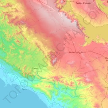
Name: Humbang Hasundutan topographic map, elevation, terrain.
Location: Humbang Hasundutan, North Sumatra, Indonesia (2.00854 98.24160 2.48712 98.97265)
Average elevation: 903 m
Minimum elevation: -1 m
Maximum elevation: 2,126 m
Make a donation
Gear up for your next adventure:
As an Amazon Associate, this site earns from qualifying purchases at no extra cost to you.
Other topographic maps
Click on a map to view its topography, its elevation and its terrain.
Make a donation
Gear up for your next adventure:
As an Amazon Associate, this site earns from qualifying purchases at no extra cost to you.
Dolok Sibualbuali
Indonesia > North Sumatra > South Tapanuli > Labuhan Rasoki
Average elevation: 1,504 m
Make a donation
Gear up for your next adventure:
As an Amazon Associate, this site earns from qualifying purchases at no extra cost to you.