
Make a donation
Gear up for your next adventure:
As an Amazon Associate, this site earns from qualifying purchases at no extra cost to you.
West Rainton topographic map
Click on the map to display elevation.
Make a donation
Gear up for your next adventure:
As an Amazon Associate, this site earns from qualifying purchases at no extra cost to you.
West Rainton
The following is from History, Topography and Directory of Durham, Whellan, London, 1894; "The village of West Rainton is about four miles north-east of Durham, and formerly contained an ancient chapel with chantry dedicated to the Virgin Mary; some of the old stones may be seen in the different buildings in the village. The Old Hall, situated in the centre of the village, was built about 1690, by Sir Jno. Buck, [sic] now in a state of dilapidation, and let in tenements occupied by pitmen. There is a library, reading, and news-room here. There are two batteries of the Second Durham Artillery Volunteers, having a drill-hall here, built by the Marquess of Londonderry in 1880, the headquarters being at Seaham Harbour."[6]
Make a donation
Gear up for your next adventure:
As an Amazon Associate, this site earns from qualifying purchases at no extra cost to you.
About this map
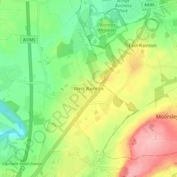
Name: West Rainton topographic map, elevation, terrain.
Average elevation: 79 m
Minimum elevation: 20 m
Maximum elevation: 162 m
Make a donation
Gear up for your next adventure:
As an Amazon Associate, this site earns from qualifying purchases at no extra cost to you.
Other topographic maps
Click on a map to view its topography, its elevation and its terrain.
Make a donation
Gear up for your next adventure:
As an Amazon Associate, this site earns from qualifying purchases at no extra cost to you.