Geolocate

Consett topographic map

Click on the map to display elevation.

About this map

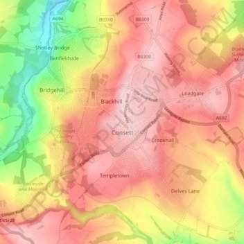
Name: Consett topographic map, elevation, terrain.

Location: Consett, County Durham, North East, England, United Kingdom (54.82807 -1.88241 54.88004 -1.80089)

Average elevation: 205 m

Minimum elevation: 80 m

Maximum elevation: 277 m

Other topographic maps

Click on a map to view its topography, its elevation and its terrain.

Durham

United Kingdom > England > County Durham

Average elevation: 119 m

Flint Hill

United Kingdom > England > County Durham

Average elevation: 191 m

Wycliffe

United Kingdom > England > County Durham

Average elevation: 129 m

Thornberry

United Kingdom > England > County Durham

Average elevation: 255 m

Toronto

United Kingdom > England > County Durham > Toronto

Average elevation: 107 m

West Rainton

United Kingdom > England > County Durham

The following is from History, Topography and Directory of Durham, Whellan, London, 1894; "The village of West Rainton is about four miles north-east of Durham, and formerly contained an ancient chapel with chantry dedicated to the Virgin Mary; some of the old stones may be seen in the different buildings in…

Average elevation: 79 m

Gear up for your next adventure:

🧥Waterproof Hiking Jacket - Protect yourself from rain and wind while hiking
🧥Thermal Fleece Jacket - Versatile insulation for changing mountain temperatures
🥾Waterproof Hiking Shoes - Durable shoes for wet and rugged trails
🔦LED Headlamp - Hands-free lighting for early morning starts or late finishes
🧴Outdoor Sunscreen - High SPF protection for high-altitude UV exposure

As an Amazon Associate, this site earns from qualifying purchases at no extra cost to you.