Geolocate

Puracé topographic map

Click on the map to display elevation.

About this map

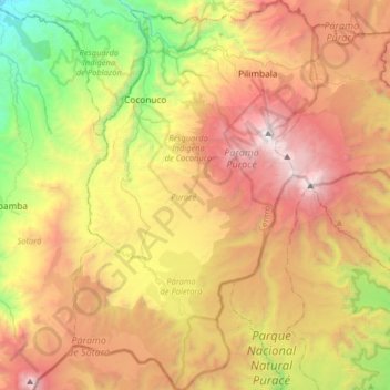
Name: Puracé topographic map, elevation, terrain.

Location: Puracé, Centro, Cauca, RAP Pacífico, Colombia (2.10106 -76.55644 2.42353 -76.35277)

Average elevation: 3,121 m

Minimum elevation: 1,756 m

Maximum elevation: 4,635 m

Other topographic maps

Click on a map to view its topography, its elevation and its terrain.

Coconuco

Colombia > Cauca > Puracé

Average elevation: 2,721 m

Las Botas

Colombia > Cauca > El Tambo

Average elevation: 1,729 m

Chamon

Colombia > Cauca > Guapi

Average elevation: 2 m

Loma Grande

Colombia > Cauca > San Sebastián

Average elevation: 2,130 m

Lopez

Colombia > Cauca > Toribío

Average elevation: 3,087 m

Chisquio

Colombia > Cauca > El Tambo

Average elevation: 1,772 m

Galíndez

Colombia > Cauca

Average elevation: 594 m

Puracé

Colombia > Cauca > Puracé > Puracé

Average elevation: 2,678 m

Gear up for your next adventure:

💡LED Camping Lantern - Illuminate your campsite with long-lasting lanterns
🕶️Polarized Sunglasses - Protect your eyes with durable polarized lenses
🧰Multitool Knife - Compact and versatile tool for outdoor use
💧Collapsible Water Bottle - Space-saving water bottle for outdoor activities
🧢Sun Hat - Wide-brim hat for sun protection

As an Amazon Associate, this site earns from qualifying purchases at no extra cost to you.