Geolocate

Borrello topographic map

Click on the map to display elevation.

About this map

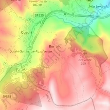
Name: Borrello topographic map, elevation, terrain.

Location: Borrello, Chieti, Abruzzo, Italy (41.89387 14.28509 41.93679 14.34715)

Average elevation: 712 m

Minimum elevation: 359 m

Maximum elevation: 963 m

Other topographic maps

Click on a map to view its topography, its elevation and its terrain.

Vallone di Santo Spirito

Italy > Abruzzo > Chieti > Fara San Martino

Average elevation: 1,273 m

Buonanotte

Italy > Abruzzo > Chieti > Vasto

Average elevation: 43 m

Fallascoso

Italy > Abruzzo > Chieti > Torricella Peligna

Average elevation: 839 m

Casali

Italy > Abruzzo > Chieti > Schiavi di Abruzzo

Average elevation: 734 m

Coderuto

Italy > Abruzzo > Chieti > Torrevecchia Teatina

Average elevation: 77 m

Foro

Italy > Abruzzo > Chieti > Miglianico

Average elevation: 143 m

Aquilano

Italy > Abruzzo > Chieti > Ortona > Aquilano

Average elevation: 86 m

Gear up for your next adventure:

🧴Insect Repellent - Protect yourself from bugs during outdoor adventures
🕶️Polarized Sunglasses - Protect your eyes with durable polarized lenses
🔪Outdoor Multitool - Versatile tool for repairs and food prep in the wild
🪑Ultralight Camping Stool - Compact seating for rest stops during long hikes
🧴Sunscreen SPF - Broad-spectrum sunscreen for outdoor activities

As an Amazon Associate, this site earns from qualifying purchases at no extra cost to you.