Geolocate

Bolbok topographic map

Click on the map to display elevation.

About this map

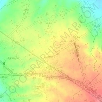
Name: Bolbok topographic map, elevation, terrain.

Location: Bolbok, Gahol, Taal, Batangas, Calabarzon, 4208, Philippines (13.88467 120.95129 13.89382 120.95808)

Average elevation: 117 m

Minimum elevation: 65 m

Maximum elevation: 153 m

Other topographic maps

Click on a map to view its topography, its elevation and its terrain.

Laguile

Philippines > Batangas > Taal

Average elevation: 38 m

Ipil

Philippines > Batangas > Taal

Average elevation: 37 m

Apacay

Philippines > Batangas > Taal

Average elevation: 49 m

Laguile

Philippines > Batangas > Taal

Average elevation: 38 m

Ipil

Philippines > Batangas > Taal

Average elevation: 37 m

Ipil

Philippines > Batangas > Taal

Average elevation: 37 m

Carasuche

Philippines > Batangas > Taal

Average elevation: 96 m

Cawit

Philippines > Batangas > Taal

Average elevation: 39 m

Poblacion 13

Philippines > Batangas > Taal > Poblacion 13

Average elevation: 38 m

Gear up for your next adventure:

🎒Hiking Daypack - Lightweight and durable backpacks for day trips and excursions
🥾Waterproof Hiking Shoes - Durable shoes for wet and rugged trails
🧥Packable Rain Jacket - Breathable waterproof layer for unpredictable weather
🥫Freeze-Dried Meals - Lightweight, high-calorie nutrition for multi-day treks
🥾Light Trekking Boots - Supportive boots for multi-day treks

As an Amazon Associate, this site earns from qualifying purchases at no extra cost to you.