Geolocate

Ipil topographic map

Click on the map to display elevation.

About this map

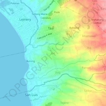
Name: Ipil topographic map, elevation, terrain.

Location: Ipil, Taal, Batangas, Calabarzon, 4208, Philippines (13.85068 120.90466 13.89068 120.94466)

Average elevation: 37 m

Minimum elevation: 0 m

Maximum elevation: 113 m

Other topographic maps

Click on a map to view its topography, its elevation and its terrain.

Bolbok

Philippines > Batangas > Taal

Average elevation: 117 m

Pansol

Philippines > Batangas > Taal

Average elevation: 69 m

Gear up for your next adventure:

🧣Evaporative Cooling Towel - Beat the heat during intense summer climbs
💧Filtered Water Bottle - Safe drinking water on the go
🛶Kayak Accessories - Essential gear for safe and fun kayaking adventures
🎒Backpack Rain Cover - External shield to keep your entire pack dry
🥫Freeze-Dried Meals - Lightweight, high-calorie nutrition for multi-day treks

As an Amazon Associate, this site earns from qualifying purchases at no extra cost to you.