Geolocate

Piai Cape topographic map

Click on the map to display elevation.

About this map

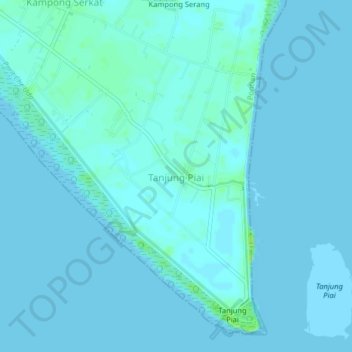
Name: Piai Cape topographic map, elevation, terrain.

Location: Piai Cape, Pontian, Johor, 82300, Malaysia (1.26357 103.48224 1.30357 103.52224)

Average elevation: 2 m

Minimum elevation: 0 m

Maximum elevation: 14 m

Other topographic maps

Click on a map to view its topography, its elevation and its terrain.

Johor Bahru

Malaysia > Johor

Average elevation: 27 m

Kota Tinggi

Malaysia > Johor

Average elevation: 29 m

Big Island

Malaysia > Johor

Average elevation: 21 m

Kluang

Malaysia > Johor

Average elevation: 54 m

Gear up for your next adventure:

🥾Hiking Gaiters - Protect legs and shoes from mud, snow, and debris
🔦LED Headlamp - Hands-free lighting for early morning starts or late finishes
🧊Insulated Water Bottle - Keeps drinks cold in summer and prevents freezing in winter
🧦Crew Hiking Socks - Comfortable socks for long-distance hikes
🧴Waterproofing Spray - Restore the DWR coating on jackets and tents

As an Amazon Associate, this site earns from qualifying purchases at no extra cost to you.