
Make a donation
Gear up for your next adventure:
As an Amazon Associate, this site earns from qualifying purchases at no extra cost to you.
Saint-Blaise topographic map
Click on the map to display elevation.
Make a donation
Gear up for your next adventure:
As an Amazon Associate, this site earns from qualifying purchases at no extra cost to you.
About this map
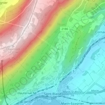
Name: Saint-Blaise topographic map, elevation, terrain.
Location: Saint-Blaise, Neuchâtel, 2072, Switzerland (47.00842 6.96427 47.05134 7.01305)
Average elevation: 687 m
Minimum elevation: 425 m
Maximum elevation: 1,178 m
Make a donation
Gear up for your next adventure:
As an Amazon Associate, this site earns from qualifying purchases at no extra cost to you.
Other topographic maps
Click on a map to view its topography, its elevation and its terrain.
La Ronde
Switzerland > Neuchâtel > Bernese Jura administrative district > La Chaux-de-Fonds
Average elevation: 807 m
Make a donation
Gear up for your next adventure:
As an Amazon Associate, this site earns from qualifying purchases at no extra cost to you.