
Wyndham-Carseland Provincial Park topographic map
Interactive map
Click on the map to display elevation.
About this map
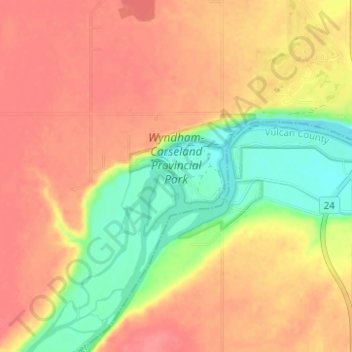
Name: Wyndham-Carseland Provincial Park topographic map, elevation, terrain.
Average elevation: 943 m
Minimum elevation: 902 m
Maximum elevation: 969 m
Other topographic maps
Click on a map to view its topography, its elevation and its terrain.
Siksika Nation
Canada > Alberta > Wheatland County
Siksika Nation, Wheatland County, Alberta, Canada
Average elevation: 922 m
Cluny
Canada > Alberta > Wheatland County > Cluny
Cluny, Wheatland County, Alberta, T0J 0S0, Canada
Average elevation: 891 m
Standard
Canada > Alberta > Wheatland County
Standard, Wheatland County, Alberta, Canada
Average elevation: 889 m
Rosebud
Canada > Alberta > Wheatland County > Rosebud
Rosebud, Wheatland County, Alberta, Canada
Average elevation: 824 m