Geolocate

Făclia topographic map

Click on the map to display elevation.

About this map
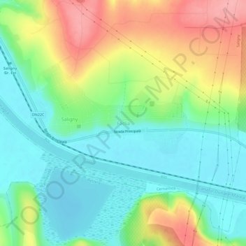
Name: Făclia topographic map, elevation, terrain.

Location: Făclia, Saligny, Constanța, 907201, Romania (44.25944 28.08279 44.29944 28.12279)

Average elevation: 44 m

Minimum elevation: 2 m

Maximum elevation: 116 m

Other topographic maps

Click on a map to view its topography, its elevation and its terrain.
Constanța

Romania > Constanța

Spring arrives early but it is quite cool. Often in April and May the Black Sea coast is one of the coolest places in Romania found at an altitude lower than 500 m (1,640 ft).

Average elevation: 19 m

Topalu

Romania > Constanța

Average elevation: 70 m

Cogealac

Romania > Constanța

Average elevation: 105 m

Vadu

Romania > Constanța

Average elevation: 13 m

Baneasa

Romania > Constanța

Average elevation: 130 m

Cernavoda

Romania > Constanța

Average elevation: 39 m

Dumbrăveni

Romania > Constanța

Average elevation: 160 m

Cogealac

Romania > Constanța

Average elevation: 97 m

Constanța

Romania > Constanța

Spring arrives early but it is quite cool. Often in April and May the Black Sea coast is one of the coolest places in Romania found at an altitude lower than 500 m (1,640 ft).

Average elevation: 19 m

Cobadin

Romania > Constanța

Average elevation: 114 m

Cernavoda

Romania > Constanța

Average elevation: 39 m

Ion Corvin

Romania > Constanța

Average elevation: 94 m

Mangalia

Romania > Constanța

Average elevation: 18 m

Constanța

Romania > Constanța > Constanța

Average elevation: 18 m

Costinești

Romania > Constanța

Average elevation: 28 m

Constanța

Romania > Constanța

Spring arrives early but it is quite cool. Often in April and May the Black Sea coast is one of the coolest places in Romania found at an altitude lower than 500 m (1,640 ft).

Average elevation: 19 m

Cumpăna

Romania > Constanța

Average elevation: 53 m

Corbu

Romania > Constanța

Average elevation: 37 m

Mamaia

Romania > Constanța > Constanța

Average elevation: 2 m

Techirghiol

Romania > Constanța

Town is in the south east extremity of Romania (Constanța County), situated on the north west shore of Lake Techirghiol (11.6 km2), elevation 15–20 m, 18 km south of the municipality of Constanța and very close to the Black Sea (3 km).

Average elevation: 23 m

Mangalia

Romania > Constanța

Mangalia is positioned at 43°49’ latitude and 28°35’ longitude, with an approximate elevation of 10 meters, 44 kilometres (27 miles) south of the municipality of Constanţa, on the same latitude as the French resort of Nice. Mangalia is one of the southernmost resorts on the Romanian coast of the Black Sea.

Average elevation: 18 m

Constanța

Romania > Constanța

Spring arrives early but it is quite cool. Often in April and May the Black Sea coast is one of the coolest places in Romania found at an altitude lower than 500 m (1,640 ft).

Average elevation: 19 m

Mihail Kogălniceanu

Romania > Constanța

Average elevation: 80 m

Constanța

Romania > Constanța

Spring arrives early but it is quite cool. Often in April and May the Black Sea coast is one of the coolest places in Romania found at an altitude lower than 500 m (1,640 ft).

Average elevation: 19 m

Constanța

Romania > Constanța

Spring arrives early but it is quite cool. Often in April and May the Black Sea coast is one of the coolest places in Romania found at an altitude lower than 500 m (1,640 ft).

Average elevation: 31 m

Săcele

Romania > Constanța

Average elevation: 57 m

Tortoman

Romania > Constanța

Average elevation: 75 m

Cernavoda

Romania > Constanța

Average elevation: 39 m

Eforie

Romania > Constanța

Average elevation: 9 m

Amzacea

Romania > Constanța

Average elevation: 86 m

Tortoman

Romania > Constanța

Average elevation: 75 m

Ovidiu

Romania > Constanța

Average elevation: 38 m

Eforie

Romania > Constanța

Average elevation: 9 m

Medgidia

Romania > Constanța

Average elevation: 67 m

Topraisar

Romania > Constanța

Average elevation: 76 m

Harsova

Romania > Constanța

Average elevation: 16 m

Gear up for your next adventure:

💧Hydration Pack - Hands-free hydration system for long hikes
🧰Emergency Multi-Tool - Compact multi-tool for outdoor survival
👟Leg Gaiters - Keep debris, mud, and snow out of your boots
👟Sport Hiking Sandals - Breathable footwear for water crossings and camp rest
🧦Merino Wool Socks - Moisture-wicking comfort for long-distance hiking

As an Amazon Associate, this site earns from qualifying purchases at no extra cost to you.