
Highland Beach topographic map
Click on the map to display elevation.
About this map
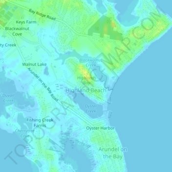
Name: Highland Beach topographic map, elevation, terrain.
Location: Highland Beach, Anne Arundel County, Maryland, United States (38.92832 -76.46978 38.93401 -76.46271)
Average elevation: 3 m
Minimum elevation: -2 m
Maximum elevation: 16 m
Other topographic maps
Click on a map to view its topography, its elevation and its terrain.
Annapolis
United States > Maryland > Anne Arundel County > Annapolis
Annapolis lies within the humid subtropical climate zone (Köppen Cfa), with hot, humid summers, cool winters, and generous precipitation year-round. Low elevation and proximity to the Chesapeake Bay give the area more moderate spring and summertime temperatures and slightly less extreme winter lows than…
Average elevation: 13 m
Glen Burnie Heights
United States > Maryland > Anne Arundel County > Glen Burnie
Average elevation: 24 m
Venice Beach
United States > Maryland > Anne Arundel County > Arundel on the Bay > Venice Beach
Average elevation: 2 m
Londontown Terrace
United States > Maryland > Anne Arundel County > Londontown Terrace
Average elevation: 4 m