Geolocate

Pasadena Beach topographic map

Click on the map to display elevation.

About this map

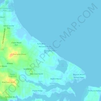
Name: Pasadena Beach topographic map, elevation, terrain.

Location: Pasadena Beach, Anne Arundel County, Maryland, United States (39.12594 -76.47774 39.16594 -76.43774)

Average elevation: 4 m

Minimum elevation: -2 m

Maximum elevation: 29 m

Other topographic maps

Click on a map to view its topography, its elevation and its terrain.

Severn

United States > Maryland > Anne Arundel County > Severn

Average elevation: 47 m

Deale

United States > Maryland > Anne Arundel County > Deale

Average elevation: 5 m

Odenton

United States > Maryland > Anne Arundel County > Odenton

Average elevation: 41 m

Gear up for your next adventure:

🧥Packable Rain Jacket - Breathable waterproof layer for unpredictable weather
🧴Waterproofing Spray - Restore the DWR coating on jackets and tents
🥾Light Hiking Boots - Lightweight and comfortable boots for day hikes
💡Solar Camping Lamp - Eco-friendly lighting for campsites
🧢Beanie Hat - Keep your head warm in cold weather

As an Amazon Associate, this site earns from qualifying purchases at no extra cost to you.