
Make a donation
Gear up for your next adventure:
As an Amazon Associate, this site earns from qualifying purchases at no extra cost to you.
Powhatan Village topographic map
Click on the map to display elevation.
Make a donation
Gear up for your next adventure:
As an Amazon Associate, this site earns from qualifying purchases at no extra cost to you.
About this map
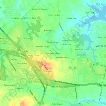
Name: Powhatan Village topographic map, elevation, terrain.
Average elevation: 19 m
Minimum elevation: -2 m
Maximum elevation: 46 m
Make a donation
Gear up for your next adventure:
As an Amazon Associate, this site earns from qualifying purchases at no extra cost to you.
Other topographic maps
Click on a map to view its topography, its elevation and its terrain.
Pasadena
United States > Maryland > Anne Arundel County > Pasadena
Pasadena is located at 39°6′46″N 76°33′7″W / 39.11278°N 76.55194°W / 39.11278; -76.55194 (39.112809, −76.551871) in northern Anne Arundel County. It is bordered to the north by the city of Baltimore, to the east by the tidal Patapsco River and by Riviera Beach, to the southeast by Lake…
Average elevation: 13 m