
Saane topographic map
Interactive map
Click on the map to display elevation.
About this map
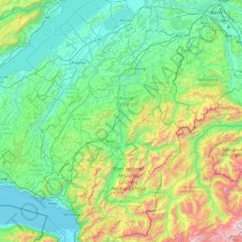
Name: Saane topographic map, elevation, terrain.
Location: Saane, Gruyère District, Fribourg, 3783, Switzerland (46.35999 7.03534 46.97950 7.29612)
Average elevation: 969 m
Minimum elevation: 367 m
Maximum elevation: 3,216 m
Other topographic maps
Click on a map to view its topography, its elevation and its terrain.
Gruyère District
Gruyère District, Fribourg, Switzerland
Average elevation: 1,232 m
Gomma
Switzerland > Fribourg > Sensebezirk > St. Silvester
Gomma, St. Silvester, Sensebezirk, Fribourg, 1735, Switzerland
Average elevation: 781 m
La Tour-de-Trême
Switzerland > Fribourg > Gruyère District > Bulle
La Tour-de-Trême, Bulle, Gruyère District, Fribourg, 1635, Switzerland
Average elevation: 758 m
Mont-Vully
Switzerland > Fribourg > See District
Mont-Vully, See District, Fribourg, Switzerland
Average elevation: 449 m
La Sarine
Switzerland > Fribourg > Sarine District > Marly
La Sarine, Marly, Sarine District, Fribourg, 1752, Switzerland
Average elevation: 622 m
Charmey
Switzerland > Fribourg > Gruyère District > Val-de-Charmey
Charmey, Val-de-Charmey, Gruyère District, Fribourg, 1637, Switzerland
Average elevation: 1,299 m
Belfaux
Switzerland > Fribourg > Sarine District > Belfaux
Belfaux, Sarine District, Fribourg, 1782, Switzerland
Average elevation: 634 m
La Sarine
Switzerland > Fribourg > Sarine District > Marly
La Sarine, Marly, Sarine District, Fribourg, 1752, Switzerland
Average elevation: 621 m
Copy
Switzerland > Fribourg > Ependes (FR)
Copy, Ependes (FR), Sarine District, Fribourg, 1731, Switzerland
Average elevation: 671 m
La Sarine
Switzerland > Fribourg > Grandvillard
La Sarine, Grandvillard, Gruyère District, Fribourg, 1666, Switzerland
Average elevation: 893 m
Creux des Tables
Switzerland > Fribourg > Châtel-Saint-Denis
Creux des Tables, Châtel-Saint-Denis, District de la Veveyse, Fribourg, 1619, Switzerland
Average elevation: 1,279 m
Avry
Switzerland > Fribourg > Avry
Avry, Sarine District, Fribourg, 1754, Switzerland
Average elevation: 662 m
Gäu
Switzerland > Fribourg > Sensebezirk > Tafers
Gäu, Tafers, Sensebezirk, Fribourg, 1712, Switzerland
Average elevation: 813 m
Broc
Switzerland > Fribourg > Broc
Broc, Gruyère District, Fribourg, 1636, Switzerland
Average elevation: 845 m