Geolocate

Mont-Vully topographic map

Click on the map to display elevation.

About this map

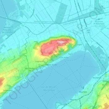
Name: Mont-Vully topographic map, elevation, terrain.

Location: Mont-Vully, See District, Fribourg, Switzerland (46.92471 7.04016 46.98490 7.15071)

Average elevation: 449 m

Minimum elevation: 423 m

Maximum elevation: 654 m

Gear up for your next adventure:

🔦LED Headtorch - Bright and durable light for night activities
🪑Ultralight Camping Stool - Compact seating for rest stops during long hikes
🧭Orienteering Kit - Tools for map reading and navigation in the wild
💡Solar Camping Lamp - Eco-friendly lighting for campsites
💡Portable Camping Lamp - Rechargeable lamp for campsite lighting

As an Amazon Associate, this site earns from qualifying purchases at no extra cost to you.