Geolocate

Lyman topographic map

Click on the map to display elevation.

About this map
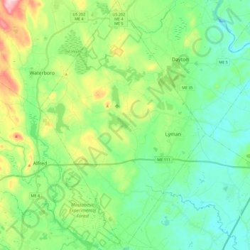
Name: Lyman topographic map, elevation, terrain.

Location: Lyman, York County, Maine, 04002, United States (43.42071 -70.71756 43.58250 -70.56951)

Average elevation: 62 m

Minimum elevation: 12 m

Maximum elevation: 150 m

Other topographic maps

Click on a map to view its topography, its elevation and its terrain.

Boon Island

United States > Maine > York County > York

Average elevation: 0 m

Lake Sherburne

United States > Maine > York County > Waterboro

Average elevation: 142 m

Wells Beach

United States > Maine > York County > Wells

Average elevation: 1 m

Jamaica Island

United States > Maine > York County > Kittery

Average elevation: 31 m

Parsons Beach

United States > Maine > York County > Kennebunk

Average elevation: 3 m

Crescent Beach

United States > Maine > York County > Kittery

Average elevation: 5 m

Rotary Park

United States > Maine > York County > Kennebunk > Kennebunk

Average elevation: 18 m

Mount Agamenticus

United States > Maine > York County > York

Average elevation: 92 m

Boon Island

United States > Maine > York County > York

Average elevation: 0 m

Mount Agamenticus

United States > Maine > York County > York

Average elevation: 92 m

Rotary Park

United States > Maine > York County > Kennebunk > Kennebunk

Average elevation: 18 m

Ogunquit Beach

United States > Maine > York County > Ogunquit

Average elevation: 11 m

Holdsworth Park

United States > Maine > York County > Sanford

Average elevation: 130 m

Gear up for your next adventure:

🔭Compact Monocular - One-handed bird watching and trail spotting
🥾Hiking Gaiters - Protect legs and shoes from mud, snow, and debris
🥾Hiking Shorts - Breathable shorts suitable for summer hikes
🍽️Titanium Camping Spork - Ultralight and indestructible eating utensil
🥾Lightweight Hiking Shoes - Comfortable shoes for day hikes

As an Amazon Associate, this site earns from qualifying purchases at no extra cost to you.