Geolocate

Banua topographic map

Click on the map to display elevation.

About this map

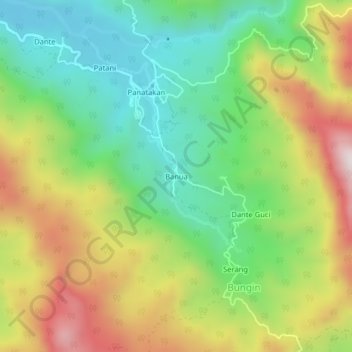
Name: Banua topographic map, elevation, terrain.

Location: Banua, Bungin, Enrekang, South Sulawesi, Sulawesi, Indonesia (-3.57525 119.94555 -3.53525 119.98555)

Average elevation: 940 m

Minimum elevation: 619 m

Maximum elevation: 1,413 m

Other topographic maps

Click on a map to view its topography, its elevation and its terrain.

Malua

Indonesia > South Sulawesi > Enrekang

Average elevation: 709 m

Alla

Indonesia > South Sulawesi > Enrekang

Average elevation: 1,037 m

Baraka

Indonesia > South Sulawesi > Enrekang

Average elevation: 827 m

Bungin

Indonesia > South Sulawesi > Enrekang

Average elevation: 1,238 m

Cendana

Indonesia > South Sulawesi > Enrekang

Average elevation: 152 m

Maiwa

Indonesia > South Sulawesi > Enrekang

Average elevation: 214 m

Malua

Indonesia > South Sulawesi > Enrekang

Average elevation: 709 m

Buntu Batu

Indonesia > South Sulawesi > Enrekang

Average elevation: 1,459 m

Gear up for your next adventure:

🧳Compression Sacks - Maximize space in your backpack by shrinking gear
🧢Outdoor Cap - Protective cap for sun and rain during hikes
🚲Heavy Duty Bike Lock - Secure your bike at the trailhead or during stops
🧰Multitool Knife - Compact and versatile tool for outdoor use
💧Collapsible Water Bottle - Space-saving water bottle for outdoor activities

As an Amazon Associate, this site earns from qualifying purchases at no extra cost to you.