Geolocate

Rampur topographic map

Click on the map to display elevation.

About this map
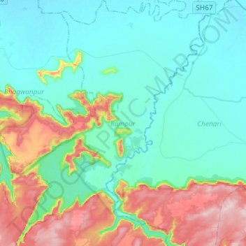
Name: Rampur topographic map, elevation, terrain.

Location: Rampur, Kaimur District, Bihar, India (24.78054 83.62810 24.99983 83.81884)

Average elevation: 179 m

Minimum elevation: 86 m

Maximum elevation: 456 m

Other topographic maps

Click on a map to view its topography, its elevation and its terrain.
Danapur

India > Bihar > Dinapur-Cum-Khagaul

Average elevation: 52 m

Kishanpur

India > Bihar > Kishanpur

Average elevation: 55 m

Kuari

India > Bihar > Dhamdaha

Average elevation: 37 m

Rusera

India > Bihar > Rosera

Average elevation: 45 m

Singheswar

India > Bihar > Singheshwar

Average elevation: 47 m

Runisaidpur

India > Bihar > Runisaidpur

Average elevation: 58 m

Maheshkhunt

India > Bihar > Gogri

Average elevation: 36 m

Gear up for your next adventure:

🕯️Camping Lantern - Illuminates your entire campsite with high-efficiency LEDs
🕶️Polarized Sunglasses - Reduces glare from snow and water at high elevations
🎒Hiking Backpack - Lightweight and ergonomic backpacks for day hikes or multi-day treks
⛺Camping Essentials - All-in-one gear for a comfortable camping trip
🥾Hiking Boots - Sturdy boots providing ankle support and traction on rugged trails

As an Amazon Associate, this site earns from qualifying purchases at no extra cost to you.