Geolocate

Ollon topographic map

Click on the map to display elevation.

About this map

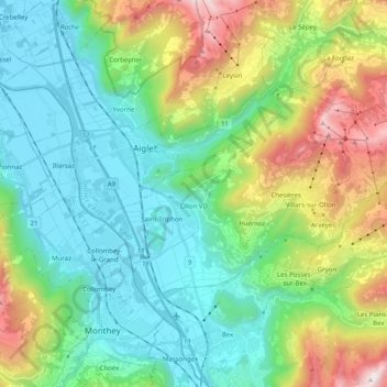
Name: Ollon topographic map, elevation, terrain.

Location: Ollon, District d'Aigle, Vaud, Switzerland (46.26394 6.94947 46.33922 7.14919)

Average elevation: 898 m

Minimum elevation: 373 m

Maximum elevation: 2,247 m

Other topographic maps

Click on a map to view its topography, its elevation and its terrain.

Vallée du Rhône

Switzerland > Vaud > District d'Aigle

Average elevation: 1,378 m

Les Diablerets

Switzerland > Vaud > District d'Aigle > Ormont-Dessus

Average elevation: 1,453 m

Villars-sur-Ollon

Switzerland > Vaud > District d'Aigle

Average elevation: 1,293 m

Les Mosses

Switzerland > Vaud > District d'Aigle > Ormont-Dessous

Average elevation: 1,634 m

Morcles

Switzerland > Vaud > District d'Aigle > Lavey-Morcles

Average elevation: 1,139 m

Chesières

Switzerland > Vaud > District d'Aigle

Average elevation: 1,247 m

Les Posses-sur-Bex

Switzerland > Vaud > District d'Aigle

Average elevation: 896 m

Les Ecovets

Switzerland > Vaud > District d'Aigle > Huémoz

Average elevation: 1,091 m

Drapel

Switzerland > Vaud > District d'Aigle > Aigle

Average elevation: 716 m

Vallée du Rhône

Switzerland > Vaud > District d'Aigle

Average elevation: 1,378 m

Chambon

Switzerland > Vaud > District d'Aigle > Roche (VD)

Average elevation: 485 m

Glacier du Dar

Switzerland > Vaud > District d'Aigle > Ormont-Dessus

Average elevation: 2,554 m

Gear up for your next adventure:

🧥Packable Rain Jacket - Breathable waterproof layer for unpredictable weather
🗺️Topographic Maps - Detailed maps to explore trails, mountains, and wilderness areas
👖Convertible Hiking Pants - Zip-off legs to adapt to changing weather conditions
🥾Hiking Gaiters - Protect legs and shoes from mud, snow, and debris
🦟Insect Repellent - Keep mosquitoes and black flies away in wooded areas

As an Amazon Associate, this site earns from qualifying purchases at no extra cost to you.