
Augher topographic map
Click on the map to display elevation.
About this map
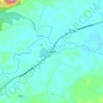
Name: Augher topographic map, elevation, terrain.
Average elevation: 73 m
Minimum elevation: 50 m
Maximum elevation: 225 m
Other topographic maps
Click on a map to view its topography, its elevation and its terrain.
Ballyard
United Kingdom > Northern Ireland > County Tyrone > Trillick > Ballyard
Average elevation: 141 m
Castlecaufield
United Kingdom > Northern Ireland > County Tyrone > Castlecaulfield
Average elevation: 95 m
Derry and Strabane District
United Kingdom > Northern Ireland > County Tyrone
Average elevation: 140 m
Errigal Keerogue
United Kingdom > Northern Ireland > County Tyrone > Ballygawley
Average elevation: 149 m