
Upper Knockando topographic map
Click on the map to display elevation.
About this map
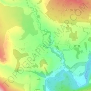
Name: Upper Knockando topographic map, elevation, terrain.
Location: Upper Knockando, Moray, Scotland, AB38 7RX, United Kingdom (57.44921 -3.38662 57.48921 -3.34662)
Average elevation: 201 m
Minimum elevation: 109 m
Maximum elevation: 349 m
Other topographic maps
Click on a map to view its topography, its elevation and its terrain.
Fochabers
United Kingdom > Scotland > Moray
The present village owes its existence to Alexander Gordon, 4th Duke of Gordon (1743–1827). During the late eighteenth century, during the Scottish Enlightenment, it was fashionable for landowners to found new towns and villages; these can be recognised all over Scotland, because unlike their predecessors…
Average elevation: 59 m