
Carrick Knowe Community Woodland topographic map
Interactive map
Click on the map to display elevation.
About this map
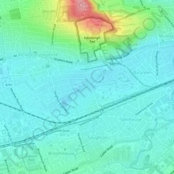
Name: Carrick Knowe Community Woodland topographic map, elevation, terrain.
Average elevation: 63 m
Minimum elevation: 38 m
Maximum elevation: 164 m
Other topographic maps
Click on a map to view its topography, its elevation and its terrain.
Holyrood Park
United Kingdom > Scotland > City of Edinburgh
Holyrood Park, City of Edinburgh, Scotland, EH8 8HG, United Kingdom
Average elevation: 67 m