
Goiás topographic map
Interactive map
Click on the map to display elevation.
Goiás
Goiás is covered with a woodland savanna known in Brazil as campo cerrado, although there are still tropical forests along the rivers. The climate of the plateau is tropical. Average monthly temperatures vary from 26 °C (79 °F) in the warmest month to 22 °C (72 °F) in the coldest. The year is divided into a rainy season (October–March) and a dry season (April–September). Average annual rainfall is about 1,700 millimetres (67 in), but this varies due to elevation and microclimate. Some parts of the state, however, have small remnants of tropical Atlantic forest, that mostly appears around rivers and valleys.
About this map
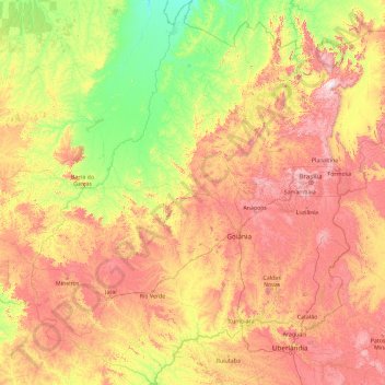
Name: Goiás topographic map, elevation, terrain.
Location: Goiás, Central-West Region, Brazil (-19.49831 -53.24856 -12.39730 -45.90716)
Average elevation: 579 m
Minimum elevation: 200 m
Maximum elevation: 1,605 m
Other topographic maps
Click on a map to view its topography, its elevation and its terrain.
São Paulo
Brazil > São Paulo > Região Metropolitana de São Paulo > São Paulo
São Paulo is in Southeastern Brazil, in southeastern São Paulo State, approximately halfway between Curitiba and Rio de Janeiro. The city is on a plateau placed beyond the Serra do Mar (Portuguese for "Sea Range" or "Coastal Range"), itself a component of the vast region known as the Brazilian Highlands,…
Average elevation: 785 m
Ilha Sumítica
Brazil > São Paulo > Região Metropolitana do Vale do Paraíba e Litoral Norte > Ilhabela
Average elevation: 1 m
Brasília
Brazil > Federal District > Região Integrada de Desenvolvimento do Distrito Federal e Entorno
The city sits at an elevation of 1,000 metres (3,300 ft) and more, high on the Brazilian Highlands in the country's center-western region. Paranoá Lake, a large artificial lake, was built to increase the amount of water available and to maintain the region's humidity. It has a marina, and hosts wakeboarders…
Average elevation: 1,084 m
Ilha Sumítica
Brazil > São Paulo > Região Metropolitana do Vale do Paraíba e Litoral Norte > Ilhabela
Average elevation: 1 m
Pico da Neblina
Brazil > Amazonas > Santa Isabel do Rio Negro
For 39 years, based on an uncontested measurement performed in 1965 by topographer José Ambrósio de Miranda Pombo, using a theodolite, the elevation of Pico da Neblina was thought to be 3,014 metres (9,888 ft), but a much more accurate measurement performed in 2004 with state-of-the-art GPS equipment by…
Average elevation: 2,178 m
Morro do Diabo
Brazil > São Paulo > Teodoro Sampaio
Its summit altitude is 650 metres (2,130 ft) (ASL). Morro do Diabo is an area landmark, seen from the valleys and plains below it. It is located near the cities of Caxias do Sul and Porto Alegre, the state capital.
Average elevation: 397 m
Pico da Neblina
Brazil > Amazonas > Santa Isabel do Rio Negro
For 39 years, based on an uncontested measurement performed in 1965 by topographer José Ambrósio de Miranda Pombo, using a theodolite, the elevation of Pico da Neblina was thought to be 3,014 metres (9,888 ft), but a much more accurate measurement performed in 2004 with state-of-the-art GPS equipment by…
Average elevation: 2,178 m
Amazon River
During what many archaeologists called the formative stage, Amazonian societies were deeply involved in the emergence of South America's highland agrarian systems. The trade with Andean civilizations in the terrains of the headwaters in the Andes formed an essential contribution to the social and religious…
Average elevation: 11 m
Praça Heitor Bastos Tigre
Brazil > Rio de Janeiro > Região Metropolitana do Rio de Janeiro > Rio de Janeiro
Average elevation: 7 m
Lagoa dos Ingleses
Brazil > Minas Gerais > Região Metropolitana de Belo Horizonte > Nova Lima
Average elevation: 1,335 m
Morro da Babilônia
Brazil > Rio de Janeiro > Região Metropolitana do Rio de Janeiro > Rio de Janeiro
Average elevation: 29 m
Chapada Diamantina
The Chapada Diamantina lies at the center of Bahia State and forms the northern part of the Espinhaço Mountain Range. The region is approximately 38,000 km2 (15,000 sq mi) in area and encompasses 58 municipalities. Technically, this region is considered a part of the caatinga biome, and contains some of its…
Average elevation: 1,390 m
Morro da Babilônia
Brazil > Rio de Janeiro > Região Metropolitana do Rio de Janeiro > Rio de Janeiro
Average elevation: 29 m
Morro da Babilônia
Brazil > Rio de Janeiro > Região Metropolitana do Rio de Janeiro > Rio de Janeiro
Average elevation: 29 m
Amazon River
During what many archaeologists called the formative stage, Amazonian societies were deeply involved in the emergence of South America's highland agrarian systems. The trade with Andean civilizations in the terrains of the headwaters in the Andes formed an essential contribution to the social and religious…
Average elevation: 5 m
Amazon River
Brazil > Amazonas > Itacoatiara
During what many archaeologists called the formative stage, Amazonian societies were deeply involved in the emergence of South America's highland agrarian systems. The trade with Andean civilizations in the terrains of the headwaters in the Andes formed an essential contribution to the social and religious…
Average elevation: 11 m
Rosa
Brazil > Goiás > Região Integrada de Desenvolvimento do Distrito Federal e Entorno > Pirenópolis
Average elevation: 780 m
Amazon River
Brazil > Amazonas > Itacoatiara
During what many archaeologists called the formative stage, Amazonian societies were deeply involved in the emergence of South America's highland agrarian systems. The trade with Andean civilizations in the terrains of the headwaters in the Andes formed an essential contribution to the social and religious…
Average elevation: 11 m
Itaipu Dam
Brazil > Paraná > Foz do Iguaçu
325 metres (1,066 ft), entire dam including the 100 metres (330 ft) high Power Line 4 Pylons atop the Barrage 260 metres (850 ft), dam + the foundation inside water until the river floor 247 metres (810 ft), 196 metres (643 ft) high of roof reinforcement concrete dam + Cranes atop the Barrage 225 metres (738…
Average elevation: 192 m
Amazon River
During what many archaeologists called the formative stage, Amazonian societies were deeply involved in the emergence of South America's highland agrarian systems. The trade with Andean civilizations in the terrains of the headwaters in the Andes formed an essential contribution to the social and religious…
Average elevation: 10 m
Corcovado
Brazil > Rio de Janeiro > Região Metropolitana do Rio de Janeiro > Rio de Janeiro
Average elevation: 221 m
Amazon River
During what many archaeologists called the formative stage, Amazonian societies were deeply involved in the emergence of South America's highland agrarian systems. The trade with Andean civilizations in the terrains of the headwaters in the Andes formed an essential contribution to the social and religious…
Average elevation: 10 m
Sitio Borda da Mata
Brazil > São Paulo > Região Metropolitana de São Paulo > Franco da Rocha
Average elevation: 793 m
Praça Bartolomeu de Messina
Brazil > São Paulo > Região Metropolitana de São Paulo > São Paulo
Average elevation: 790 m
Pico das Agulhas Negras
Brazil > Minas Gerais > Bocaina de Minas
A mountain shelter called Abrigo Rebouças is located near the base of the peak, at an elevation of about 2,350 metres (7,710 ft). It is accessible by a gravel road (BR-485) from the BR-354 federal highway at the Garganta do Registro mountain pass, via Itatiaia National Park's north entrance. The access road…
Average elevation: 2,454 m
São Francisco de Assis
Brazil > Minas Gerais > Região Metropolitana de Belo Horizonte > Lagoa Santa
Average elevation: 754 m
Amazon River
Brazil > Amazonas > Careiro da Várzea
During what many archaeologists called the formative stage, Amazonian societies were deeply involved in the emergence of South America's highland agrarian systems. The trade with Andean civilizations in the terrains of the headwaters in the Andes formed an essential contribution to the social and religious…
Average elevation: 21 m
Bosque Gutierrez
Brazil > Paraná > Região Metropolitana de Curitiba > Curitiba
Average elevation: 940 m
Amazon River
During what many archaeologists called the formative stage, Amazonian societies were deeply involved in the emergence of South America's highland agrarian systems. The trade with Andean civilizations in the terrains of the headwaters in the Andes formed an essential contribution to the social and religious…
Average elevation: 11 m
Serra da Borborema
Brazil > Paraíba > Região Metropolitana de Patos > Cacimbas
Average elevation: 573 m
Amazon River
During what many archaeologists called the formative stage, Amazonian societies were deeply involved in the emergence of South America's highland agrarian systems. The trade with Andean civilizations in the terrains of the headwaters in the Andes formed an essential contribution to the social and religious…
Average elevation: 5 m
Sugarloaf
Brazil > Rio de Janeiro > Região Metropolitana do Rio de Janeiro > Rio de Janeiro
Average elevation: 17 m