
Make a donation
Gear up for your next adventure:
As an Amazon Associate, this site earns from qualifying purchases at no extra cost to you.
Pico da Neblina topographic map
Click on the map to display elevation.
Make a donation
Gear up for your next adventure:
As an Amazon Associate, this site earns from qualifying purchases at no extra cost to you.
Pico da Neblina
For 39 years, based on an uncontested measurement performed in 1965 by topographer José Ambrósio de Miranda Pombo, using a theodolite, the elevation of Pico da Neblina was thought to be 3,014 metres (9,888 ft), but a much more accurate measurement performed in 2004 with state-of-the-art GPS equipment by cartographer Marco Aurélio de Almeida Lima, a member of a Brazilian Army expedition, put it at 2,993.78 m (9,822 ft). This was then officially recognised by the Brazilian Institute of Geography and Statistics (IBGE), the federal government's official geographic survey and census agency, which jointly organised the expedition.
Make a donation
Gear up for your next adventure:
As an Amazon Associate, this site earns from qualifying purchases at no extra cost to you.
About this map
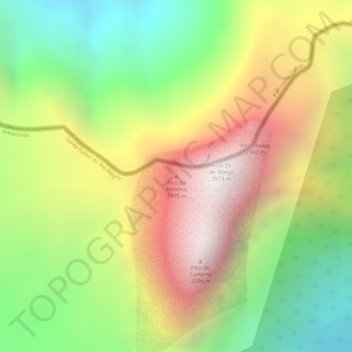
Name: Pico da Neblina topographic map, elevation, terrain.
Average elevation: 2,178 m
Minimum elevation: 1,441 m
Maximum elevation: 2,907 m
Make a donation
Gear up for your next adventure:
As an Amazon Associate, this site earns from qualifying purchases at no extra cost to you.
Other topographic maps
Click on a map to view its topography, its elevation and its terrain.