
County Carlow topographic map
Click on the map to display elevation.
County Carlow
The soils of the county are mostly derived from glacial till, rather than solid bedrock geology. These typically consist of a mix of clay, sand and gravel. Occasionally glacial melt-water would form a long ridge of sand and gravel known as an esker. One such example is preserved within the county and is a proposed natural heritage area, referred to as the Ballymoon Esker. The north of the county is generally flat, while central and southern Carlow are characterised by an undulating to rolling topography which becomes progressively hillier towards the south and east. The Blackstairs Mountains are the highest and most extensive upland area, with Mount Leinster rising to 794 m (2,605 ft), making it the highest point in both Carlow and Wexford and the seventh highest county top in Ireland.
About this map
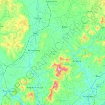
Name: County Carlow topographic map, elevation, terrain.
Location: County Carlow, Leinster, Ireland (52.46359 -7.10794 52.91802 -6.50494)
Average elevation: 126 m
Minimum elevation: 0 m
Maximum elevation: 789 m
Other topographic maps
Click on a map to view its topography, its elevation and its terrain.
Swords
Ireland > County Dublin > Swords
The medieval town developed in a linear pattern along Main Street, in a roughly north-south direction. Swords has one of the best examples of this settlement pattern in the Dublin region. The round tower, 26m in height, is also an indicator of early Christian settlement. The Irish high king Brian Boru is said…
Average elevation: 28 m
Greystones
Greystones is located south of the site of an ancient castle of the Barony of Rathdown. There was a hamlet which, like Rathdown Castle, was known as Rathdown, and which appeared on a 1712 map. This site occupied an area now known as the Grove, north of Greystones harbour, but only the ruins of a chapel, St.…
Average elevation: 49 m
Limerick
Limerick's climate is classified as temperate oceanic (Köppen Cfb). Met Éireann maintains a climatological weather station at Shannon Airport, 20 kilometres west of the city in County Clare. Shannon Airport records an average of 977 millimetres of precipitation annually, most of which is rain. Limerick has a…
Average elevation: 54 m