Geolocate

Delphi topographic map

Click on the map to display elevation.

About this map

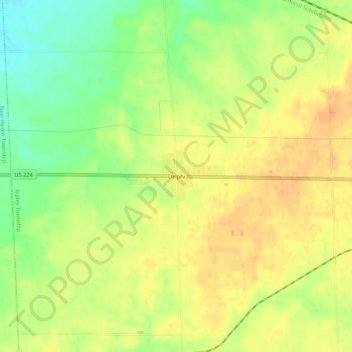
Name: Delphi topographic map, elevation, terrain.

Location: Delphi, Ripley Township, Huron County, Ohio, United States (41.01117 -82.62767 41.05117 -82.58767)

Average elevation: 314 m

Minimum elevation: 291 m

Maximum elevation: 328 m

Other topographic maps

Click on a map to view its topography, its elevation and its terrain.

Willard

United States > Ohio > Huron County

Average elevation: 284 m

Greenwich

United States > Ohio > Huron County

Average elevation: 317 m

North Fairfield

United States > Ohio > Huron County

Average elevation: 284 m

Plymouth

United States > Ohio > Huron County

Average elevation: 305 m

Holiday Lakes

United States > Ohio > Huron County

Average elevation: 263 m

New London Township

United States > Ohio > Huron County

Average elevation: 297 m

Wakeman

United States > Ohio > Huron County

Average elevation: 263 m

Monroeville

United States > Ohio > Huron County

Average elevation: 219 m

New London

United States > Ohio > Huron County

Average elevation: 304 m

Gear up for your next adventure:

🎒Backpack Rain Cover - External shield to keep your entire pack dry
Camping Coffee Maker - Brew fresh coffee anywhere on the topographic map
🕶️Polarized Sunglasses - Protect your eyes with durable polarized lenses
Tent Footprint - Protect tent floor and increase durability
🧰Multitool Knife - Compact and versatile tool for outdoor use

As an Amazon Associate, this site earns from qualifying purchases at no extra cost to you.