
Make a donation
Gear up for your next adventure:
As an Amazon Associate, this site earns from qualifying purchases at no extra cost to you.
Salem topographic map
Click on the map to display elevation.
Make a donation
Gear up for your next adventure:
As an Amazon Associate, this site earns from qualifying purchases at no extra cost to you.
About this map
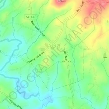
Name: Salem topographic map, elevation, terrain.
Location: Salem, Oconee County, South Carolina, United States (34.87839 -82.98540 34.89662 -82.96607)
Average elevation: 316 m
Minimum elevation: 275 m
Maximum elevation: 385 m
Make a donation
Gear up for your next adventure:
As an Amazon Associate, this site earns from qualifying purchases at no extra cost to you.
Other topographic maps
Click on a map to view its topography, its elevation and its terrain.
Woodland Trailer Park
United States > South Carolina > Oconee County > Walhalla
Average elevation: 303 m
Make a donation
Gear up for your next adventure:
As an Amazon Associate, this site earns from qualifying purchases at no extra cost to you.
Make a donation
Gear up for your next adventure:
As an Amazon Associate, this site earns from qualifying purchases at no extra cost to you.
Make a donation
Gear up for your next adventure:
As an Amazon Associate, this site earns from qualifying purchases at no extra cost to you.
George Martin Acres
United States > South Carolina > Oconee County > George Martin Acres
Average elevation: 253 m