
Make a donation
Gear up for your next adventure:
As an Amazon Associate, this site earns from qualifying purchases at no extra cost to you.
Mackinac County topographic map
Click on the map to display elevation.
Make a donation
Gear up for your next adventure:
As an Amazon Associate, this site earns from qualifying purchases at no extra cost to you.
About this map
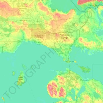
Name: Mackinac County topographic map, elevation, terrain.
Location: Mackinac County, Michigan, United States (45.71811 -85.86535 46.24568 -84.11412)
Average elevation: 206 m
Minimum elevation: 168 m
Maximum elevation: 401 m
Make a donation
Gear up for your next adventure:
As an Amazon Associate, this site earns from qualifying purchases at no extra cost to you.
Other topographic maps
Click on a map to view its topography, its elevation and its terrain.
Christie Lake
United States > Michigan > Van Buren County > Lawrence Township
Average elevation: 238 m
Make a donation
Gear up for your next adventure:
As an Amazon Associate, this site earns from qualifying purchases at no extra cost to you.
Mcnearney Lake
United States > Michigan > Chippewa County > Bay Mills Township
Average elevation: 286 m
Make a donation
Gear up for your next adventure:
As an Amazon Associate, this site earns from qualifying purchases at no extra cost to you.
Old Mission
United States > Michigan > Grand Traverse County
Old Mission is located just east of M-37 near the tip of Old Mission Peninsula about 16 miles (25.75 km) north of Traverse City. The community was built along Old Mission Harbor, which is a small safe haven along the East Arm of Grand Traverse Bay. The community sits at an elevation of 587 feet (179 m) above…
Average elevation: 190 m
Make a donation
Gear up for your next adventure:
As an Amazon Associate, this site earns from qualifying purchases at no extra cost to you.
Felch Mountain
United States > Michigan > Dickinson County > Felch Township > Felch
Average elevation: 354 m
Make a donation
Gear up for your next adventure:
As an Amazon Associate, this site earns from qualifying purchases at no extra cost to you.
Golfcrest
United States > Michigan > Monroe County > Frenchtown Charter Township
Average elevation: 181 m
Make a donation
Gear up for your next adventure:
As an Amazon Associate, this site earns from qualifying purchases at no extra cost to you.
Make a donation
Gear up for your next adventure:
As an Amazon Associate, this site earns from qualifying purchases at no extra cost to you.
Genessee County Recreational Area
United States > Michigan > Genesee County > Genesee Charter Township
Average elevation: 231 m
Mount Arvon
United States > Michigan > Baraga County > L'Anse Township
Mount Arvon (/ɑːrvɒn/ ARR-vahn) at 1,979 feet (603 m), is the highest natural point in the U.S. state of Michigan. Located in L'Anse Township, Baraga County, Mount Arvon is part of the Huron Mountains. It rises about eight miles (13 km) south of Lake Superior (elevation 591 feet [180 m]). On the list of…
Average elevation: 526 m
Make a donation
Gear up for your next adventure:
As an Amazon Associate, this site earns from qualifying purchases at no extra cost to you.
Charlevoix South Pier Light
United States > Michigan > Charlevoix County > Charlevoix
Average elevation: 180 m
Make a donation
Gear up for your next adventure:
As an Amazon Associate, this site earns from qualifying purchases at no extra cost to you.
Make a donation
Gear up for your next adventure:
As an Amazon Associate, this site earns from qualifying purchases at no extra cost to you.
Make a donation
Gear up for your next adventure:
As an Amazon Associate, this site earns from qualifying purchases at no extra cost to you.
Lower Peninsula Experimental Forest
United States > Michigan > Wexford County > South Branch Township
Average elevation: 314 m
Echo Lake
United States > Michigan > Kent County > Grand Rapids Charter Township
Average elevation: 240 m
Make a donation
Gear up for your next adventure:
As an Amazon Associate, this site earns from qualifying purchases at no extra cost to you.
Make a donation
Gear up for your next adventure:
As an Amazon Associate, this site earns from qualifying purchases at no extra cost to you.
Make a donation
Gear up for your next adventure:
As an Amazon Associate, this site earns from qualifying purchases at no extra cost to you.
Make a donation
Gear up for your next adventure:
As an Amazon Associate, this site earns from qualifying purchases at no extra cost to you.
Make a donation
Gear up for your next adventure:
As an Amazon Associate, this site earns from qualifying purchases at no extra cost to you.
Boyne Mountain
United States > Michigan > Charlevoix County > Boyne Valley Township
Average elevation: 263 m
Make a donation
Gear up for your next adventure:
As an Amazon Associate, this site earns from qualifying purchases at no extra cost to you.
Make a donation
Gear up for your next adventure:
As an Amazon Associate, this site earns from qualifying purchases at no extra cost to you.
Make a donation
Gear up for your next adventure:
As an Amazon Associate, this site earns from qualifying purchases at no extra cost to you.
Make a donation
Gear up for your next adventure:
As an Amazon Associate, this site earns from qualifying purchases at no extra cost to you.
Van Riper State Park
United States > Michigan > Marquette County > Michigamme Township
Average elevation: 489 m
Make a donation
Gear up for your next adventure:
As an Amazon Associate, this site earns from qualifying purchases at no extra cost to you.
Grand Mere State Park
United States > Michigan > Berrien County > Lincoln Charter Township
Average elevation: 185 m
Make a donation
Gear up for your next adventure:
As an Amazon Associate, this site earns from qualifying purchases at no extra cost to you.
Hulbert
United States > Michigan > Chippewa County > Hulbert Township
Hulbert is a rural community in western Chippewa County in the Upper Peninsula. The community is located within Hulbert Township about 40 miles (64 km) south of the Tahquamenon Falls. The community sits at an elevation of 751 feet (229 m) above sea level.
Average elevation: 231 m
Make a donation
Gear up for your next adventure:
As an Amazon Associate, this site earns from qualifying purchases at no extra cost to you.
Anchor Bay Shores
United States > Michigan > Macomb County > Chesterfield Township
Average elevation: 176 m
Make a donation
Gear up for your next adventure:
As an Amazon Associate, this site earns from qualifying purchases at no extra cost to you.
Lookout Point
United States > Michigan > Grand Traverse County > Peninsula Township
Average elevation: 188 m
Metamora-Hadley State Recreation Area
United States > Michigan > Lapeer County > Metamora
Average elevation: 298 m
Make a donation
Gear up for your next adventure:
As an Amazon Associate, this site earns from qualifying purchases at no extra cost to you.
Make a donation
Gear up for your next adventure:
As an Amazon Associate, this site earns from qualifying purchases at no extra cost to you.