Geolocate

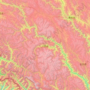
Pasho County topographic map

Click on the map to display elevation.

Pasho County

The county is highly mountainous, with an average elevation of about 3,260 metres (10,700 ft) above sea level. Pasho County contains the Brahmaputra–Salween water divide. The Ngajuk La pass (29°40′07″N 96°43′05″E / 29.6687°N 96.7181°E / 29.6687; 96.7181 (Ngajuk La)) is on the divide. To the north, Ling Chu flows north and east draining into Salween. To the south, Parlung Tsangpo flows south and west to drain into the Tsangpo River (the Tibetan section of Brahmaputra). Pasho County hosts the Rakwa Tso lake and the Laigu Glacier [zh].

Wikipedia (CC-BY-SA 3.0)

About this map

Name: Pasho County topographic map, elevation, terrain.

Location: Pasho County, Chamdo City, Xizang, China (29.12510 96.30128 31.01555 97.44620)

Average elevation: 4,541 m

Minimum elevation: 2,420 m

Maximum elevation: 6,564 m

Other topographic maps

Click on a map to view its topography, its elevation and its terrain.

Rixung

China > Xizang > Chamdo City

Average elevation: 4,259 m

Mount Kailash

China > Xizang > Purang County > Parga town

Mount Kailash (also Kailasa; Kangrinboqê or Gang Rinpoche; Tibetan: གངས་རིན་པོ་ཆེ; simplified Chinese: 冈仁波齐峰; traditional Chinese: 岡仁波齊峰; Sanskrit: कैलास, IAST: Kailāsa), is a mountain in the Ngari Prefecture, Tibet Autonomous Region of China. It has an…

Average elevation: 5,756 m
Everest Base Camp

China > Xizang > Tingri County > Tashi Dzom town

Average elevation: 5,377 m

Gangqên

China > Xizang > Baqên County > Marru township

Average elevation: 4,521 m

Kardung

China > Xizang > Purang County > Purang

Average elevation: 5,098 m

Bangbu

China > Xizang > Lhari County > Lhari town

Average elevation: 4,840 m

Namcha Barwa

China > Xizang > Mainling City

Average elevation: 6,698 m

Bé

China > Xizang > Zayu County

Average elevation: 2,474 m

卡拉

China > Xizang > Bomê County > Yi'ong township

Average elevation: 3,779 m

Rinchen Bumpa

China > Xizang > Lhodrak County

Average elevation: 3,969 m

Tacai La

China > Xizang > Yadong County > Chomodoi township

Average elevation: 4,498 m

Senqiong La

China > Xizang > Yadong County > Chomodoi township

Average elevation: 4,358 m

Chidê

China > Xizang > Purang County > Purang

Average elevation: 3,986 m

Namcha Barwa

China > Xizang > Mainling City

Average elevation: 6,698 m

Chumbi Valley

China > Xizang > Yadong County > Xiayadong Township > Rinchengang

The valley is at an altitude of 3,000 m (9,800 ft), and being on the south side of the Himalayas, enjoys a wetter and more temperate climate than most of Tibet. The valley supports some vegetation in the form of the Eastern Himalayan broadleaf forests and transitions to the Eastern Himalayan alpine shrub and…

Average elevation: 3,076 m

Goinsar

China > Xizang > Nyalam County > Dram town

Average elevation: 2,421 m

Qoidên

China > Xizang > Chamdo City

Average elevation: 3,962 m

Dê’gyiling

China > Xizang > Ngamring County > Kagar town

Average elevation: 4,637 m

Raorang

China > Xizang > Lhuntse County > Doyul township

Average elevation: 3,609 m

Nai

China > Xizang > Tingri County > Shelkar town

Average elevation: 4,422 m

Nyingchi

China > Xizang

Average elevation: 4,035 m

Lhakü

China > Xizang > Dinggyê County > Qab township

Average elevation: 4,298 m

Sulu La

China > Xizang > Dinggyê County > Zhêntang

Average elevation: 4,161 m

Torsa Nala

China > Xizang > Yadong County > Xiayadong Township

Average elevation: 2,980 m

Kunlun Mountains

China > Xizang > Rutog County > Dongru township

Average elevation: 6,188 m

Mount Kailash

China > Xizang > Purang County > Parga town

Mount Kailash (also Kailasa, Gang Tise and Gang Rinpoche or Kangrinboqê) is a mountain in Ngari Prefecture, Tibet Autonomous Region of China. It lies in the Gangdise Shan mountain range of the Transhimalaya, in the western part of the Tibetan Plateau. The peak of Mount Kailash is located at an elevation of…

Average elevation: 5,756 m
Tibetan Plateau

China > Xizang > Nyima County > Nyima town

Average elevation: 4,498 m

Yarlung Tsangpo

China > Xizang > Gonggar County > Qangtang town

Average elevation: 3,621 m

Namcha Barwa

China > Xizang > Mainling City

Average elevation: 6,698 m

Gear up for your next adventure:

⛺Camping Tent - Weather-resistant tents suitable for 2 to 6 people
🥾Approach Boots - Comfortable boots for hiking and climbing approaches
🧦Hiking Socks - Moisture-wicking and comfortable socks for long hikes
🎒Fully Waterproof Backpack - Total protection for photography gear and electronics
🧰Survival Kit - Essential gear for emergencies in the wilderness

As an Amazon Associate, this site earns from qualifying purchases at no extra cost to you.