Geolocate

Princeville topographic map

Click on the map to display elevation.

About this map

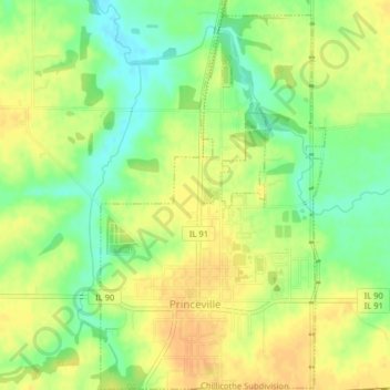
Name: Princeville topographic map, elevation, terrain.

Location: Princeville, Peoria County, Illinois, United States (40.92316 -89.76732 40.95331 -89.74420)

Average elevation: 220 m

Minimum elevation: 201 m

Maximum elevation: 233 m

Other topographic maps

Click on a map to view its topography, its elevation and its terrain.

Trivoli

United States > Illinois > Peoria County

Average elevation: 224 m

Monica

United States > Illinois > Peoria County

Average elevation: 230 m

Kickapoo

United States > Illinois > Peoria County

Average elevation: 198 m

Peoria

United States > Illinois > Peoria County > Peoria

Average elevation: 196 m

Gear up for your next adventure:

🛁Quick-Dry Microfiber Towel - Space-saving towel that dries rapidly on the move
🥾Trail Hiking Socks - Comfortable socks to prevent blisters and fatigue
🧰Survival Kit - Essential gear for emergencies in the wilderness
🥾Trekking Poles - Adjustable trekking poles to reduce knee stress and improve stability
🕶️Polarized Sunglasses - Protect your eyes with durable polarized lenses

As an Amazon Associate, this site earns from qualifying purchases at no extra cost to you.