Geolocate

Litchfield topographic map

Click on the map to display elevation.

About this map

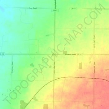
Name: Litchfield topographic map, elevation, terrain.

Location: Litchfield, Litchfield Township, Medina County, Ohio, 44253, United States (41.14783 -82.04292 41.18783 -82.00292)

Average elevation: 306 m

Minimum elevation: 275 m

Maximum elevation: 335 m

Other topographic maps

Click on a map to view its topography, its elevation and its terrain.

Brunswick

United States > Ohio > Medina County

Average elevation: 339 m

Medina

United States > Ohio > Medina County

Average elevation: 320 m

Montville Township

United States > Ohio > Medina County

Average elevation: 341 m

Lodi

United States > Ohio > Medina County

Average elevation: 295 m

Seville

United States > Ohio > Medina County

Average elevation: 317 m

Wadsworth

United States > Ohio > Medina County

Average elevation: 348 m

Medina

United States > Ohio > Medina County

Average elevation: 320 m

Hinckley Township

United States > Ohio > Medina County

Average elevation: 336 m

Lafayette Township

United States > Ohio > Medina County

Average elevation: 333 m

Wadsworth

United States > Ohio > Medina County

Average elevation: 348 m

Medina Township

United States > Ohio > Medina County

Average elevation: 307 m

Brunswick

United States > Ohio > Medina County

Average elevation: 339 m

Montville Township

United States > Ohio > Medina County

Average elevation: 341 m

Sharon Township

United States > Ohio > Medina County

Average elevation: 343 m

Gear up for your next adventure:

🧥Softshell Hiking Jacket - The perfect balance of wind protection and breathability
🔦LED Headtorch - Bright and durable light for night activities
🥾Hiking Shoes - Durable and comfortable shoes for trail hiking
🛁Quick-Dry Microfiber Towel - Space-saving towel that dries rapidly on the move
🧦Hiking Socks - Moisture-wicking and comfortable socks for long hikes

As an Amazon Associate, this site earns from qualifying purchases at no extra cost to you.