Geolocate

Brunswick topographic map

Click on the map to display elevation.

About this map

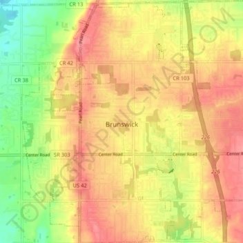
Name: Brunswick topographic map, elevation, terrain.

Location: Brunswick, Medina County, Ohio, 44212, United States (41.21619 -81.86069 41.27645 -81.78491)

Average elevation: 339 m

Minimum elevation: 294 m

Maximum elevation: 368 m

Other topographic maps

Click on a map to view its topography, its elevation and its terrain.

Abbeyville

United States > Ohio > Medina County

Average elevation: 278 m

Hinckley

United States > Ohio > Medina County

Average elevation: 330 m

Litchfield

United States > Ohio > Medina County

Average elevation: 306 m

Valley City

United States > Ohio > Medina County

Average elevation: 262 m

Valley City

United States > Ohio > Medina County

Average elevation: 262 m

Valley City

United States > Ohio > Medina County

Average elevation: 262 m

Wadsworth

United States > Ohio > Medina County > Wadsworth

Average elevation: 344 m

Gear up for your next adventure:

🔥Camping Stove - Portable stoves to cook outdoors with ease
🥾Trail Hiking Socks - Comfortable socks to prevent blisters and fatigue
🧢Beanie Hat - Keep your head warm in cold weather
🥾Mountaineering Boots - Supportive boots for climbing and high-altitude hiking
🛏️Camping Sleeping Mat - Comfortable mats for sleeping outdoors

As an Amazon Associate, this site earns from qualifying purchases at no extra cost to you.