Geolocate

Loch Earn topographic map

Click on the map to display elevation.

About this map

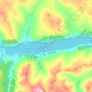
Name: Loch Earn topographic map, elevation, terrain.

Location: Loch Earn, Lochearnhead, Stirling, Scotland, United Kingdom (56.37766 -4.28109 56.39702 -4.11469)

Average elevation: 393 m

Minimum elevation: 89 m

Maximum elevation: 975 m

Other topographic maps

Click on a map to view its topography, its elevation and its terrain.

Glen Ogle

United Kingdom > Scotland > Stirling > Lochearnhead

Average elevation: 463 m

Lochearnhead

United Kingdom > Scotland > Stirling > Lochearnhead

Average elevation: 274 m

Gear up for your next adventure:

🏃Hydration Running Vest - Carry water and maps close to your body for speed
🐕Hiking Dog Pack - Let your canine companion carry their own water and food
🚲Heavy Duty Bike Lock - Secure your bike at the trailhead or during stops
🥫Freeze-Dried Meals - Lightweight, high-calorie nutrition for multi-day treks
🪑Ultralight Camping Stool - Compact seating for rest stops during long hikes

As an Amazon Associate, this site earns from qualifying purchases at no extra cost to you.