
Kabinakagamisis Lake topographic map
Interactive map
Click on the map to display elevation.
About this map
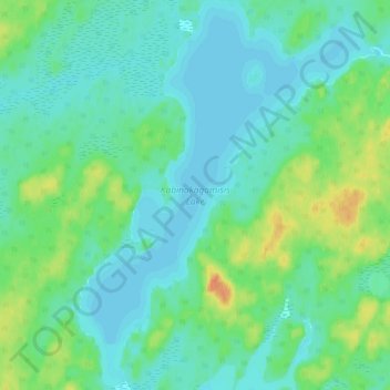
Name: Kabinakagamisis Lake topographic map, elevation, terrain.
Average elevation: 324 m
Minimum elevation: 313 m
Maximum elevation: 353 m
Other topographic maps
Click on a map to view its topography, its elevation and its terrain.
Ogidaki
Canada > Ontario > Algoma District > Unorganized North Algoma
Ogidaki, Unorganized North Algoma, Algoma District, Northeastern Ontario, Ontario, Canada
Average elevation: 371 m
Alpha Lake
Canada > Ontario > Algoma District > Unorganized North Algoma
Alpha Lake, Unorganized North Algoma, Algoma District, Northeastern Ontario, Ontario, Canada
Average elevation: 314 m
Limerick Lake
Canada > Ontario > Algoma District > Unorganized North Algoma
Limerick Lake, Unorganized North Algoma, Algoma District, Northeastern Ontario, Ontario, Canada
Average elevation: 505 m
Tilley Lakes
Canada > Ontario > Algoma District > Unorganized North Algoma
Tilley Lakes, Unorganized North Algoma, Algoma District, Northeastern Ontario, Ontario, Canada
Average elevation: 301 m
Montreal River
Canada > Ontario > Algoma District > Unorganized North Algoma
Montreal River, Unorganized North Algoma, Algoma District, Northeastern Ontario, Ontario, Canada
Average elevation: 360 m
Kimiwan Creek;Kimiwan Lakes
Canada > Ontario > Algoma District > Unorganized North Algoma
Kimiwan Creek;Kimiwan Lakes, Unorganized North Algoma, Algoma District, Northeastern Ontario, Ontario, Canada
Average elevation: 442 m
Agawa Canyon
Canada > Ontario > Algoma District > Unorganized North Algoma
Agawa Canyon, Unorganized North Algoma, Algoma District, Northeastern Ontario, Ontario, Canada
Average elevation: 409 m
Fire River
Canada > Ontario > Algoma District > Unorganized North Algoma
Fire River, Unorganized North Algoma, Algoma District, Northeastern Ontario, Ontario, Canada
Average elevation: 399 m
Goulais River
Canada > Ontario > Algoma District > Unorganized North Algoma
Goulais River, Unorganized North Algoma, Algoma District, Northeastern Ontario, Ontario, Canada
Average elevation: 362 m
Mosambik Lake
Canada > Ontario > Algoma District > Unorganized North Algoma
Mosambik Lake, Unorganized North Algoma, Algoma District, Northeastern Ontario, Ontario, Canada
Average elevation: 363 m
Manitowik Lake
Canada > Ontario > Algoma District > Unorganized North Algoma
Manitowik Lake, Unorganized North Algoma, Algoma District, Northeastern Ontario, Ontario, Canada
Average elevation: 394 m
Batchawana Bay
Canada > Ontario > Algoma District > Unorganized North Algoma
Batchawana Bay, Unorganized North Algoma, Algoma District, Northeastern Ontario, Ontario, P0S 1A0, Canada
Average elevation: 198 m
Northland Lake
Canada > Ontario > Algoma District > Unorganized North Algoma
Northland Lake, Unorganized North Algoma, Algoma District, Northeastern Ontario, Ontario, Canada
Average elevation: 387 m
Ella Lake
Canada > Ontario > Algoma District > Unorganized North Algoma
Ella Lake, Unorganized North Algoma, Algoma District, Northeastern Ontario, Ontario, Canada
Average elevation: 479 m
Goulais Bay
Canada > Ontario > Algoma District > Unorganized North Algoma
Goulais Bay, Unorganized North Algoma, Algoma District, Northeastern Ontario, Ontario, Canada
Average elevation: 189 m
Kabinakagami Lake
Canada > Ontario > Algoma District > Unorganized North Algoma
Kabinakagami Lake, Unorganized North Algoma, Algoma District, Northeastern Ontario, Ontario, Canada
Average elevation: 332 m
Chapleau River
Canada > Ontario > Algoma District > Unorganized North Algoma
Chapleau River, Unorganized North Algoma, Algoma District, Northeastern Ontario, Ontario, Canada
Average elevation: 328 m
Searchmont
Canada > Ontario > Algoma District > Unorganized North Algoma
Searchmont, Unorganized North Algoma, Algoma District, Northeastern Ontario, Ontario, P0S 1J0, Canada
Average elevation: 261 m
Montreal River
Canada > Ontario > Algoma District > Unorganized North Algoma
Montreal River, Unorganized North Algoma, Algoma District, Northeastern Ontario, Ontario, Canada
Average elevation: 209 m
Lanier Lake
Canada > Ontario > Algoma District > Unorganized North Algoma
Lanier Lake, Unorganized North Algoma, Algoma District, Northeastern Ontario, Ontario, Canada
Average elevation: 403 m
Cedar Falls
Canada > Ontario > Algoma District > Unorganized North Algoma
Cedar Falls, Unorganized North Algoma, Algoma District, Northeastern Ontario, Ontario, Canada
Average elevation: 345 m
Albany Forks
Canada > Ontario > Algoma District > Unorganized North Algoma
Albany Forks, Unorganized North Algoma, Algoma District, Northeastern Ontario, Ontario, Canada
Average elevation: 324 m
Seymour Lake
Canada > Ontario > Algoma District > Unorganized North Algoma
Seymour Lake, Unorganized North Algoma, Algoma District, Northeastern Ontario, Ontario, Canada
Average elevation: 436 m
Dog Lake
Canada > Ontario > Algoma District > Unorganized North Algoma
Dog Lake, Unorganized North Algoma, Algoma District, Northeastern Ontario, Ontario, Canada
Average elevation: 364 m
Missanabie
Canada > Ontario > Algoma District > Unorganized North Algoma
Missanabie, Unorganized North Algoma, Algoma District, Northeastern Ontario, Ontario, P0M 2H0, Canada
Average elevation: 339 m
Harmony Beach
Canada > Ontario > Algoma District > Unorganized North Algoma
Harmony Beach, Unorganized North Algoma, Algoma District, Northeastern Ontario, Ontario, Canada
Average elevation: 232 m
Wabos
Canada > Ontario > Algoma District > Unorganized North Algoma
Wabos, Unorganized North Algoma, Algoma District, Northeastern Ontario, Ontario, Canada
Average elevation: 336 m