
Make a donation
Gear up for your next adventure:
As an Amazon Associate, this site earns from qualifying purchases at no extra cost to you.
Mauna Loa topographic map
Click on the map to display elevation.
Make a donation
Gear up for your next adventure:
As an Amazon Associate, this site earns from qualifying purchases at no extra cost to you.
About this map
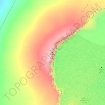
Name: Mauna Loa topographic map, elevation, terrain.
Location: Mauna Loa, Hawaiʻi County, Hawaii, United States (19.47548 -155.60575 19.47558 -155.60565)
Average elevation: 4,037 m
Minimum elevation: 3,860 m
Maximum elevation: 4,184 m
Make a donation
Gear up for your next adventure:
As an Amazon Associate, this site earns from qualifying purchases at no extra cost to you.
Other topographic maps
Click on a map to view its topography, its elevation and its terrain.
Maui County
At its lowest, near the ocean, the National Park has a tropical rainforest climate bordering a tropical monsoon climate. However, as altitudes progresses the climate becomes oceanic/Mediterranean, reaching, at the very top of Haleakalā, an alpine climate.
Average elevation: 949 m
Make a donation
Gear up for your next adventure:
As an Amazon Associate, this site earns from qualifying purchases at no extra cost to you.
Make a donation
Gear up for your next adventure:
As an Amazon Associate, this site earns from qualifying purchases at no extra cost to you.