
Le Pont topographic map
Interactive map
Click on the map to display elevation.
About this map
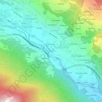
Name: Le Pont topographic map, elevation, terrain.
Location: Le Pont, La Salle, Vallée d'Aoste, 11015, Italie (45.72387 7.04314 45.76387 7.08314)
Average elevation: 1,190 m
Minimum elevation: 807 m
Maximum elevation: 2,165 m
Other topographic maps
Click on a map to view its topography, its elevation and its terrain.
Planaval
Italie > Vallée d'Aoste > La Salle
Planaval, La Salle, Vallée d'Aoste, 11015, Italie
Average elevation: 1,999 m
Cheverel
Italie > Vallée d'Aoste > La Salle > Cheverel
Cheverel, La Salle, Vallée d'Aoste, 11015, Italie
Average elevation: 1,511 m
Chabodey
Italie > Vallée d'Aoste > La Salle > Chabodey
Chabodey, La Salle, Vallée d'Aoste, 11015, Italie
Average elevation: 1,218 m