
Make a donation
Gear up for your next adventure:
As an Amazon Associate, this site earns from qualifying purchases at no extra cost to you.
Sungai Batu topographic map
Click on the map to display elevation.
Make a donation
Gear up for your next adventure:
As an Amazon Associate, this site earns from qualifying purchases at no extra cost to you.
About this map
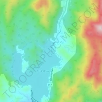
Name: Sungai Batu topographic map, elevation, terrain.
Average elevation: 227 m
Minimum elevation: 77 m
Maximum elevation: 565 m
Make a donation
Gear up for your next adventure:
As an Amazon Associate, this site earns from qualifying purchases at no extra cost to you.
Other topographic maps
Click on a map to view its topography, its elevation and its terrain.
Kampung Indian Settlement Batu Caves
Malaysia > Selangor > Selayang Municipal Council > Batu Caves
Average elevation: 68 m
Kampung Melayu Pekan Rawang
Malaysia > Selangor > Selayang Municipal Council > Rawang
Average elevation: 48 m
Kampung Indian Settlement Batu Caves
Malaysia > Selangor > Selayang Municipal Council > Batu Caves
Average elevation: 68 m
Make a donation
Gear up for your next adventure:
As an Amazon Associate, this site earns from qualifying purchases at no extra cost to you.
Kampung Selayang Baru
Malaysia > Selangor > Selayang Municipal Council > Batu Caves
Average elevation: 73 m
Make a donation
Gear up for your next adventure:
As an Amazon Associate, this site earns from qualifying purchases at no extra cost to you.
Kampung Selayang Indah
Malaysia > Selangor > Selayang Municipal Council > Batu Caves
Average elevation: 71 m
Kampung Laksamana
Malaysia > Selangor > Selayang Municipal Council > Batu Caves
Average elevation: 78 m
Kampung Sri Gombak Indah
Malaysia > Selangor > Selayang Municipal Council > Batu Caves
Average elevation: 84 m
Make a donation
Gear up for your next adventure:
As an Amazon Associate, this site earns from qualifying purchases at no extra cost to you.
Kampung Indian Settlement Batu Caves
Malaysia > Selangor > Selayang Municipal Council > Batu Caves
Average elevation: 68 m
Make a donation
Gear up for your next adventure:
As an Amazon Associate, this site earns from qualifying purchases at no extra cost to you.
Kampung Gombak Utara
Malaysia > Selangor > Selayang Municipal Council > Gombak
Average elevation: 121 m
Kampung Baru Batu Caves
Malaysia > Selangor > Selayang Municipal Council > Batu Caves
Average elevation: 69 m
Make a donation
Gear up for your next adventure:
As an Amazon Associate, this site earns from qualifying purchases at no extra cost to you.
Kampung Melayu Pekan Rawang
Malaysia > Selangor > Selayang Municipal Council > Rawang
Average elevation: 48 m
Kampung Orang Asli Sungai Relang
Malaysia > Selangor > Selayang Municipal Council
Average elevation: 368 m
Kampung Melayu Pekan Rawang
Malaysia > Selangor > Selayang Municipal Council > Rawang
Average elevation: 48 m
Make a donation
Gear up for your next adventure:
As an Amazon Associate, this site earns from qualifying purchases at no extra cost to you.
Kampung Selayang Baru
Malaysia > Selangor > Selayang Municipal Council > Batu Caves
Average elevation: 73 m
Kampung Indian Settlement Batu Caves
Malaysia > Selangor > Selayang Municipal Council > Batu Caves
Average elevation: 68 m
Make a donation
Gear up for your next adventure:
As an Amazon Associate, this site earns from qualifying purchases at no extra cost to you.
Kampung Melayu Pekan Rawang
Malaysia > Selangor > Selayang Municipal Council > Rawang
Average elevation: 48 m
Make a donation
Gear up for your next adventure:
As an Amazon Associate, this site earns from qualifying purchases at no extra cost to you.
Kampung Indian Settlement Batu Caves
Malaysia > Selangor > Selayang Municipal Council > Batu Caves
Average elevation: 68 m
Dark Cave (Closed)
Malaysia > Selangor > Selayang Municipal Council > Batu Caves
Average elevation: 73 m
Make a donation
Gear up for your next adventure:
As an Amazon Associate, this site earns from qualifying purchases at no extra cost to you.
Kampung Sungai Serai
Malaysia > Selangor > Selayang Municipal Council > Kampung Sungai Serai
Average elevation: 54 m
Make a donation
Gear up for your next adventure:
As an Amazon Associate, this site earns from qualifying purchases at no extra cost to you.
Kampung Baru Batu Caves
Malaysia > Selangor > Selayang Municipal Council > Batu Caves
Average elevation: 68 m
Kampung Melayu Pekan Rawang
Malaysia > Selangor > Selayang Municipal Council > Rawang
Average elevation: 48 m
Make a donation
Gear up for your next adventure:
As an Amazon Associate, this site earns from qualifying purchases at no extra cost to you.
Kampung Selayang Indah
Malaysia > Selangor > Selayang Municipal Council > Batu Caves > Kampung Selayang Indah
Average elevation: 76 m