
Make a donation
Gear up for your next adventure:
As an Amazon Associate, this site earns from qualifying purchases at no extra cost to you.
Kampung Kenanga topographic map
Click on the map to display elevation.
Make a donation
Gear up for your next adventure:
As an Amazon Associate, this site earns from qualifying purchases at no extra cost to you.
About this map
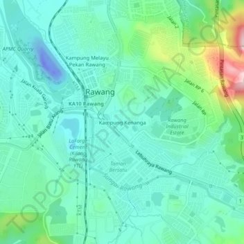
Name: Kampung Kenanga topographic map, elevation, terrain.
Average elevation: 62 m
Minimum elevation: -56 m
Maximum elevation: 281 m
Make a donation
Gear up for your next adventure:
As an Amazon Associate, this site earns from qualifying purchases at no extra cost to you.
Other topographic maps
Click on a map to view its topography, its elevation and its terrain.
Sungai Pajam
Malaysia > Selangor > Selayang Municipal Council > Rawang > Kampung Sungai Samak
Average elevation: 51 m
Kampung Desa Kuala Garing
Malaysia > Selangor > Selayang Municipal Council > Rawang
Average elevation: 35 m
Sungai Pajam
Malaysia > Selangor > Selayang Municipal Council > Rawang > Kampung Sungai Samak
Average elevation: 86 m