Geolocate

Youngstown topographic map

Click on the map to display elevation.

About this map

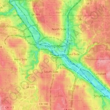
Name: Youngstown topographic map, elevation, terrain.

Location: Youngstown, Mahoning County, Ohio, United States (41.04995 -80.71118 41.13901 -80.56793)

Average elevation: 307 m

Minimum elevation: 249 m

Maximum elevation: 355 m

Other topographic maps

Click on a map to view its topography, its elevation and its terrain.

Austintown

United States > Ohio > Mahoning County

Average elevation: 318 m

Lake Milton

United States > Ohio > Mahoning County

Average elevation: 299 m

Austintown

United States > Ohio > Mahoning County

Average elevation: 318 m

Uptown

United States > Ohio > Mahoning County > Youngstown

Average elevation: 314 m

Fosterville

United States > Ohio > Mahoning County > Youngstown

Average elevation: 313 m

North Jackson

United States > Ohio > Mahoning County

Average elevation: 311 m

Stony Ridge

United States > Ohio > Mahoning County > Austintown

Average elevation: 310 m

North Lima

United States > Ohio > Mahoning County

Average elevation: 335 m

Gear up for your next adventure:

🧴Sunscreen SPF - Broad-spectrum sunscreen for outdoor activities
Camping Groundsheet - Protect your tent from moisture and dirt
🚲Bike Repair Kit - Essential tools for on-trail mechanical issues
🧦Thermal Socks - Warm socks for winter hiking or camping
🧦Crew Hiking Socks - Comfortable socks for long-distance hikes

As an Amazon Associate, this site earns from qualifying purchases at no extra cost to you.