Geolocate

Rubiás topographic map

Click on the map to display elevation.

About this map

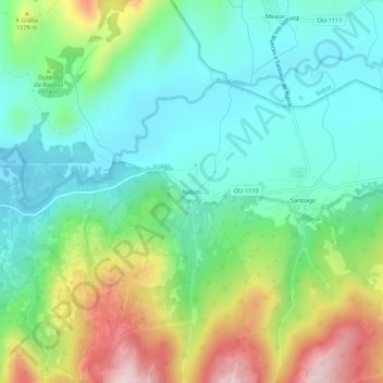
Name: Rubiás topographic map, elevation, terrain.

Location: Rubiás, Rubiás dos Mixtos, Calvos de Randín, A Limia, Ourense, Galicia, 32646, España (41.88869 -7.85313 41.92869 -7.81313)

Average elevation: 968 m

Minimum elevation: 832 m

Maximum elevation: 1,267 m

Other topographic maps

Click on a map to view its topography, its elevation and its terrain.

Porqueira

España > Galicia > A Limia

Average elevation: 752 m

Baltar

España > Galicia > A Limia

Average elevation: 926 m

Rairiz de Veiga

España > Galicia > A Limia

Average elevation: 699 m

Vilar de Barrio

España > Galicia > A Limia

Average elevation: 720 m

Sandiás

España > Galicia > A Limia

El relieve del término municipal está caracterizado por la tierra desecada de la antigua laguna de Antela por el este y por las elevaciones que hacen de límite occidental de la comarca de La Limia, que alcanzan los 892 metros en el pico Cantariñas por el oeste. La altitud oscila entre los 892 metros al…

Average elevation: 661 m

Calvos de Randín

España > Galicia > A Limia

Average elevation: 983 m

Gear up for your next adventure:

🧴Sunscreen SPF - Broad-spectrum sunscreen for outdoor activities
🦶Anti-Blister Balm - Prevents friction and hotspots during long ascents
🥾All-Terrain Hiking Boots - Versatile boots for varied hiking conditions
🦯Trekking Poles - Reduced impact on joints for steep topographic climbs
💧Hydration Bladder - Hands-free hydration solution for long treks

As an Amazon Associate, this site earns from qualifying purchases at no extra cost to you.