Geolocate

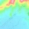
Porqueira topographic map

Click on the map to display elevation.

About this map

Name: Porqueira topographic map, elevation, terrain.

Location: Porqueira, A Limia, Ourense, Galicia, Spain (41.98717 -7.92662 42.06195 -7.78645)

Average elevation: 752 m

Minimum elevation: 563 m

Maximum elevation: 1,096 m

Other topographic maps

Click on a map to view its topography, its elevation and its terrain.
Perrelos

Spain > Galicia > A Limia > Sarreaus

Average elevation: 673 m

Gear up for your next adventure:

🧤Insulated Winter Gloves - Heavy-duty protection for sub-zero Canadian adventures
⛺Camping Tent - Weather-resistant tents suitable for 2 to 6 people
🧢Hiking Hat - Sun-protective and breathable hats for long treks
🧴Bear Spray Holster - Quick-access carry for essential Canadian wilderness safety
📷Outdoor Action Camera - Capture high-elevation views and rugged adventures

As an Amazon Associate, this site earns from qualifying purchases at no extra cost to you.