Geolocate

Baltar topographic map

Click on the map to display elevation.

About this map

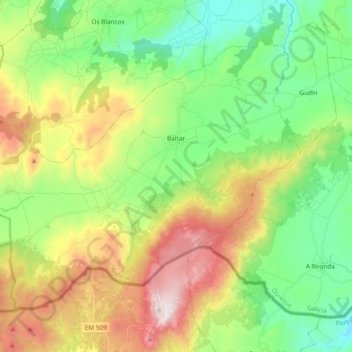
Name: Baltar topographic map, elevation, terrain.

Location: Baltar, A Limia, Ourense, Galicia, 32633, Spain (41.88197 -7.83769 41.98991 -7.64885)

Average elevation: 926 m

Minimum elevation: 584 m

Maximum elevation: 1,523 m

Other topographic maps

Click on a map to view its topography, its elevation and its terrain.

Perrelos

Spain > Galicia > A Limia > Sarreaus

Average elevation: 673 m

Gear up for your next adventure:

🧥Waterproof Jacket - Lightweight rain jackets for hiking and outdoor activities
🥾Waterproof Trail Shoes - Shoes designed to handle wet terrain
🎒Fully Waterproof Backpack - Total protection for photography gear and electronics
🧥Thermal Layer - Insulating layer for cold outdoor conditions
🧥Softshell Hiking Jacket - The perfect balance of wind protection and breathability

As an Amazon Associate, this site earns from qualifying purchases at no extra cost to you.