
Kalimantan central topographic map
Interactive map
Click on the map to display elevation.
About this map
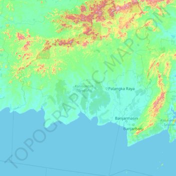
Name: Kalimantan central topographic map, elevation, terrain.
Location: Kalimantan central, Indonésie (-5.18827 110.67955 0.79541 115.84880)
Average elevation: 100 m
Minimum elevation: -1 m
Maximum elevation: 2,127 m
Other topographic maps
Click on a map to view its topography, its elevation and its terrain.
Melata
Indonésie > Kalimantan central > Lamandau
Melata, Lamandau, Kalimantan central, Kalimantan, Indonésie
Average elevation: 28 m
Pasir Panjang
Indonésie > Kalimantan central
Pasir Panjang, Kalimantan central, 74181, Indonésie
Average elevation: 17 m
Sungai Sampit
Indonésie > Kalimantan central
Sungai Sampit, Kalimantan central, Indonésie
Average elevation: 15 m