Geolocate

Whitmore topographic map

Click on the map to display elevation.

About this map

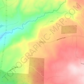
Name: Whitmore topographic map, elevation, terrain.

Location: Whitmore, Shasta County, California, 96096, United States (40.60932 -121.93666 40.64932 -121.89666)

Average elevation: 659 m

Minimum elevation: 483 m

Maximum elevation: 795 m

Other topographic maps

Click on a map to view its topography, its elevation and its terrain.

Shasta Lake

United States > California > Shasta County

Average elevation: 265 m

Shingletown

United States > California > Shasta County

Average elevation: 920 m

Anderson

United States > California > Shasta County

Average elevation: 151 m

Gear up for your next adventure:

🔥Emergency Fire Starter - Reliable ignition source for all weather conditions
🥾Lightweight Hiking Boots - Boots for comfort and mobility on long hikes
🔦LED Flashlight - Powerful and long-lasting flashlight for camping and emergencies
🦟Insect Repellent - Keep mosquitoes and black flies away in wooded areas
🦶Anti-Blister Balm - Prevents friction and hotspots during long ascents

As an Amazon Associate, this site earns from qualifying purchases at no extra cost to you.